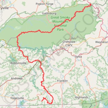
Great Smoky Mountains Appalachian Trail
Hike through Great Smoky Mountains along Appalachian Trail via Standing Indian, Ridgepole Mountain, Yellow Bald, Wine Spring Bald, Copper Ridge Bald, Cheoah Bald, Wauchecha Bald, Fontana Dam, Thunderhead Mountain, Clingmans Dome, Mount Kephart and Mount Guyot. #Hike #Mountain #Nature #Forest #Lake #Appalachian
- Distance: 144.0 mi
- Elevation gain: 29,111 ft
- Maximum elevation: 6,604 ft
- Elevation loss: 31,877 ft
- Minimum elevation: 1,411 ft
- Moving time: 3 d 7 h
- Moving speed: 1.8 mph
- Maximum speed: 36.4 mph
- Total time: 12 d 13 h
- Global speed: 0.5 mph
Interactive map
GPS track profile
About this GPS track
Name: Great Smoky Mountains Appalachian Trail GPS track, route, trail
Coordinates: 34.99901 -83.82150 35.78614 -83.10171
Topography: Clay County topographic map, elevation, terrain
Other GPS tracks
Click on a GPS track to view its route, statistics and profile.
Mount LeConte, Myrtle Point and Cliff Top via Alum Cave Trail in Great Smoky Mountains National Park
United States > Tennessee > Sevier County
The Alum Cave Trail to Mount LeConte offers a stunning and challenging hike through the Great Smoky Mountains. Starting with gentle inclines through lush forest, highlights include crossing Alum Cave Creek, the natural arch of Arch Rock, and panoramic views from Inspiration Point. Beyond the iconic Alum Cave…
Distance: 12.0 mi • Elevation gain: 3,957 ft • Maximum elevation: 6,542 ft
Grotto Falls via Trillium Gap Trail in Great Smoky Mountains National Park
United States > Tennessee > Sevier County
The hike to Grotto Falls offers a refreshing woodland experience within Great Smoky Mountains National Park. The trail takes you through a lush forest, featuring streams and wildflowers, leading to the 25-foot high Grotto Falls, where you can walk behind the waterfall—a rare and exciting feature of the hike.…
Distance: 2.7 mi • Elevation gain: 925 ft • Maximum elevation: 3,819 ft
Chimney Tops Trail in Great Smoky Mountains National Park
United States > Tennessee > Sevier County > Fort Harry
The Chimney Tops Trail is a well-loved hiking route known for its stunning mountain vistas and diverse natural beauty. This trail features a steep ascent, crossing several picturesque streams and providing breathtaking views, particularly of Mount LeConte and Sugarland Mountain, along its path. This trail is a…
Distance: 4.0 mi • Elevation gain: 1,581 ft • Maximum elevation: 4,708 ft
Charlies Bunion via Appalachian Trail from Newfound Gap in Great Smoky Mountains National Park
United States > North Carolina > Swain County
The hike to Charlies Bunion is a rewarding experience characterized by stunning panoramic views of the Great Smoky Mountains. As you traverse the Appalachian Trail, you'll encounter diverse landscapes, including dense forests of Fraser fir and red spruce, as well as several scenic overlooks that reveal…
Distance: 8.2 mi • Elevation gain: 2,224 ft • Maximum elevation: 6,073 ft
Laurel Falls Trail in Great Smoky Mountains National Park
United States > Tennessee > Sevier County
The Laurel Falls Trail offers a delightful experience as it leads hikers through a picturesque landscape filled with vibrant mountain laurel blooms in spring. The trail, while moderately challenging with some steep sections, is mostly paved, making it accessible for a wide range of visitors. Upon reaching the…
Distance: 2.6 mi • Elevation gain: 682 ft • Maximum elevation: 2,697 ft
Rainbow Falls Trail in Great Smoky Mountains National Park
United States > Tennessee > Sevier County
The Rainbow Falls Trail offers a breathtaking experience with its lush, forested pathways leading to the stunning Rainbow Falls, known for its impressive 80-foot drop. Along the hike, visitors can enjoy views of LeConte Creek, several picturesque footbridges, and vibrant wildflowers in spring. This moderately…
Distance: 5.4 mi • Elevation gain: 1,916 ft • Maximum elevation: 4,314 ft
Alum Cave Trail to Peregrine Peak in Great Smoky Mountains National Park
United States > Tennessee > Sevier County
Hiking the Alum Cave Trail to Peregrine Peak offers an immersive experience through a stunning old-growth forest, with highlights including the dramatic Arch Rock and the expansive views from Inspiration Point. The trail features a mix of steep ascents and unique geological formations, making it both…
Distance: 4.7 mi • Elevation gain: 1,591 ft • Maximum elevation: 5,115 ft
Mount LeConte and Cliff Top via Alum Cave Trail in Great Smoky Mountains National Park
United States > Tennessee > Sevier County
The hike to Mount LeConte and Cliff Top via Alum Cave Trail is a challenging yet rewarding journey through some of the most iconic landscapes in the Great Smoky Mountains National Park. The trail passes notable landmarks like Arch Rock and Alum Cave Bluff, with expansive mountain views from Inspiration Point.…
Distance: 11.6 mi • Elevation gain: 3,871 ft • Maximum elevation: 6,542 ft
Mount Le Conte - High Top
United States > Tennessee > Sevier County
Hike from Alum Cave Bluffs Trailhead to Mount Le Conte via Walker Camp Prong, Alum Cave Trail, Peregrine Peak, Cliff Top, Bull Head Trail and Boulevard Trail in the Great Smoky Mountains National Park. #Hike #Mountain #Nature #Forest
Distance: 11.2 mi • Elevation gain: 4,613 ft • Maximum elevation: 6,542 ft
Appalachian Trail : Charlies Bunyon, Mount Kephart and Mount Ambler from Newfound Gap
United States > Tennessee > Sevier County
Distance: 8.8 mi • Elevation gain: 2,451 ft • Maximum elevation: 6,152 ft
Franklin - Lee Creek - Rainbow Springs
United States > North Carolina > Macon County > Franklin
Distance: 47.4 mi • Elevation gain: 7,766 ft • Maximum elevation: 3,934 ft