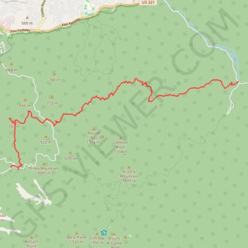
Grapeyard Ridge Trail to Baskins Creek Falls
Hike from Greenbrier Road to Cherokee Orchard Road via Grapeyard Ridge Trail, Baskins Creek Trail and Baskins Creek Falls in the Great Smoky Mountains National Park. #Hike #Nature #Mountain #Forest #Park #Falls #River
- Distance: 10.9 mi
- Elevation gain: 3,333 ft
- Maximum elevation: 3,022 ft
- Elevation loss: 2,385 ft
- Minimum elevation: 1,693 ft
- Moving time: 5 h 35 m
- Moving speed: 2.0 mph
- Maximum speed: 3.1 mph
- Total time: 5 h 57 m
- Global speed: 1.8 mph
- Date: 03/21/2020
Interactive map
GPS track profile
About this GPS track
Name: Grapeyard Ridge Trail to Baskins Creek Falls GPS track, route, trail
Coordinates: 35.67709 -83.48242 35.70923 -83.38259
Topography: Sevier County topographic map
Other GPS tracks
Click on a GPS track to view route, its statistics and profile.
Great Smoky Mountains Appalachian Trail
United States > North Carolina > Clay County
Hike through Great Smoky Mountains along Appalachian Trail via Standing Indian, Ridgepole Mountain, Yellow Bald, Wine Spring Bald, Copper Ridge Bald, Cheoah Bald, Wauchecha Bald, Fontana Dam, Thunderhead Mountain, Clingmans Dome, Mount Kephart and Mount Guyot. #Hike #Mountain #Nature #Forest #Lake #Appalachian
Distance: 144.0 mi • Elevation gain: 29,111 ft • Maximum elevation: 6,604 ft