Mount LeConte, Cliff Top and Myrtle Point
Hike to Mount LeConte, Cliff Top and Myrtle Point via Alum Cave Trail, Cliff Top Trail and Boulevard Trail in the Great Smoky Mountains National Park. #Hike #Mountain #Forest #Nature #Park
- Distance: 6.1 mi
- Elevation gain: 3,346 ft
- Maximum elevation: 6,542 ft
- Elevation loss: 801 ft
- Minimum elevation: 3,881 ft
Interactive map
GPS track profile
About this GPS track
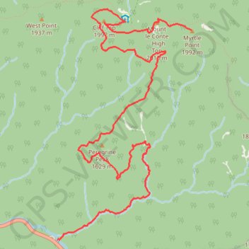
Name: Mount LeConte, Cliff Top and Myrtle Point GPS track, route, trail
Start: Alum Cave Trail, Sevier County, East Tennessee, Tennessee, United States (35.62917 -83.45084)
End: Boulevard Trail, Sevier County, East Tennessee, Tennessee, United States (35.65338 -83.43186)
Coordinates: 35.62917 -83.45084 35.65577 -83.43186
Topography: Sevier County topographic map, elevation, terrain
Other GPS tracks
Click on a GPS track to view its route, statistics and profile.
Mount LeConte, Myrtle Point and Cliff Top via Alum Cave Trail in Great Smoky Mountains National Park
United States > Tennessee > Sevier County
The Alum Cave Trail to Mount LeConte offers a stunning and challenging hike through the Great Smoky Mountains. Starting with gentle inclines through lush forest, highlights include crossing Alum Cave Creek, the natural arch of Arch Rock, and panoramic views from Inspiration Point. Beyond the iconic Alum Cave…
Distance: 12.0 mi • Elevation gain: 3,957 ft • Maximum elevation: 6,542 ft
Alum Cave Trail to Peregrine Peak in Great Smoky Mountains National Park
United States > Tennessee > Sevier County
Hiking the Alum Cave Trail to Peregrine Peak offers an immersive experience through a stunning old-growth forest, with highlights including the dramatic Arch Rock and the expansive views from Inspiration Point. The trail features a mix of steep ascents and unique geological formations, making it both…
Distance: 4.7 mi • Elevation gain: 1,591 ft • Maximum elevation: 5,115 ft
Mount LeConte and Cliff Top via Alum Cave Trail in Great Smoky Mountains National Park
United States > Tennessee > Sevier County
The hike to Mount LeConte and Cliff Top via Alum Cave Trail is a challenging yet rewarding journey through some of the most iconic landscapes in the Great Smoky Mountains National Park. The trail passes notable landmarks like Arch Rock and Alum Cave Bluff, with expansive mountain views from Inspiration Point.…
Distance: 11.6 mi • Elevation gain: 3,871 ft • Maximum elevation: 6,542 ft
Great Smoky Mountains Appalachian Trail
United States > North Carolina > Clay County
Hike through Great Smoky Mountains along Appalachian Trail via Standing Indian, Ridgepole Mountain, Yellow Bald, Wine Spring Bald, Copper Ridge Bald, Cheoah Bald, Wauchecha Bald, Fontana Dam, Thunderhead Mountain, Clingmans Dome, Mount Kephart and Mount Guyot. #Hike #Mountain #Nature #Forest #Lake #Appalachian
Distance: 144.0 mi • Elevation gain: 29,111 ft • Maximum elevation: 6,604 ft
Mount Le Conte - High Top
United States > Tennessee > Sevier County
Hike from Alum Cave Bluffs Trailhead to Mount Le Conte via Walker Camp Prong, Alum Cave Trail, Peregrine Peak, Cliff Top, Bull Head Trail and Boulevard Trail in the Great Smoky Mountains National Park. #Hike #Mountain #Nature #Forest
Distance: 11.2 mi • Elevation gain: 4,613 ft • Maximum elevation: 6,542 ft