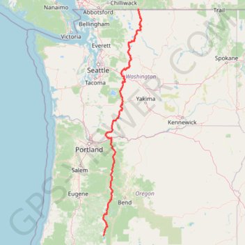
Northern part of the Pacific Crest Trail (PCT)
Hike on the Pacific Crest National Scenic Trail from Crater Lake to Canada Border through Oregon and Washington along the Sierra Nevada and Cascade mountain ranges. #Hike #Mountain #SierraNevada #Cascade #Nature #Forest #Park #PCT
- Distance: 744.6 mi
- Elevation gain: 145,367 ft
- Maximum elevation: 7,569 ft
- Elevation loss: 147,631 ft
- Minimum elevation: 69 ft
Interactive map
GPS track profile
About this GPS track
Name: Northern part of the Pacific Crest Trail (PCT) GPS track, route, trail
End: Pacific Crest Trail, Okanogan County, Washington, United States (49.00024 -120.80226)
Coordinates: 42.99581 -122.14350 49.00024 -120.66450
Topography: Klamath County topographic map
Other GPS tracks
Click on a GPS track to view route, its statistics and profile.
Peter Skene Ogden Trail to the Paulina Lake
United States > Oregon > Deschutes County
Hike to the Paulina Lake by the Peter Skene Ogden Trail along the Paulina Creek via McKay Crossing Falls and Paulina Falls in the Newberry National Volcanic Monument and the Deschutes National Forest. #Hike #Mountain #River #Forest #Falls #Nature #Volcano #Lake
Distance: 8.5 mi • Elevation gain: 2,073 ft • Maximum elevation: 6,358 ft
Chain Lakes and Wild Goose Trails Loop
United States > Washington > Whatcom County
Loop hike via Bagley Dam, Chain Lakes Trail, Bagley Lakes, Iceberg Lake, Mazama Lake, Wild Goose Trail, Terminal Lake and Heather Meadows in the Mount Baker Wilderness. #Hike #Loop #Lake #Nature #Mountain #River #Forest #Wilderness
Distance: 7.7 mi • Elevation gain: 2,044 ft • Maximum elevation: 5,466 ft
Cougar Mountain Loop
United States > Washington > King County > Issaquah
Loop hike to Cougar Mountain via Talus Bridge Trail, Bear Ridge Trail, West Tibbetts Creek Trail, Tibbetts Marsh Trail, Lost Beagle Trail, Southeast Cougar Mountain Drive, Shangri La Trail, No Name Trail, Surprise Creek Trail, Precipice Top Trail, Military Ridge Trail, Trearis Trail and Shangri-La Way Northwest in the Cougar Mountain…
Distance: 5.3 mi • Elevation gain: 1,175 ft • Maximum elevation: 1,490 ft
Panorama Point, Golden Gate Falls and Myrtle Falls Loop
United States > Washington > Pierce County > Paradise
Loop hike from Paradise to Panorama Point via Relief Map of Mount Rainier, Skyline Trail, Dead Horse Creek Trail, Glacier Vista Trail, Glacier Vista, Upper Skyline Trail, Golden Gate Trail, Golden Gate Falls and Myrtle Falls Viewpoint in the Mount Rainier National Park and the Paradise Park. #Hike #Loop #Mountain #Nature #Forest…
Distance: 4.7 mi • Elevation gain: 1,759 ft • Maximum elevation: 7,044 ft
Multnomah Falls, Ecola Falls and Wahkeena Falls Loop
United States > Oregon > Multnomah County
Loop hike via Larch Mountain Trail, Benson Bridge, Lower Multnomah Falls, Dutchman Falls, Wiesendanger Falls, Ecola Falls, Wahkeena Trail, Fairy Falls, Lemmons Viewpoint, Wahkeena Falls and Return Trail in the Mount Hood National Forest above the Benson Lake and the Columbia River. #Hike #Loop #Falls #River #Nature #Mountain #Forest…
Distance: 5.7 mi • Elevation gain: 3,419 ft • Maximum elevation: 1,660 ft
Eagle Creek and Falls
United States > Oregon > Hood River County
Hike from Columbia River to the Wahtum Lake along Eagle Creek via Metlako Falls, Sorenson Falls, Punch Bowl Falls, Four Mile Falls, Wy east Falls, Grand Union Falls, Tunnel Falls and Twister Falls in the Mark O. Hatfield Wilderness. #Hike #River #Falls #Canyon #Forest #Mountain #Lake #Wilderness
Distance: 13.1 mi • Elevation gain: 5,833 ft • Maximum elevation: 3,753 ft
Post Canyon
United States > Oregon > Hood River County
#MTB
Distance: 13.9 mi • Elevation gain: 2,579 ft • Maximum elevation: 2,444 ft
Richmond Mine Trail
Distance: 8.9 mi • Elevation gain: 3,232 ft • Maximum elevation: 6,201 ft
Captain Point
United States > Washington > King County
Distance: 9.1 mi • Elevation gain: 3,094 ft • Maximum elevation: 5,594 ft
Expedition to Sedum Ridge
United States > Oregon > Multnomah County
Distance: 133.4 mi • Elevation gain: 16,709 ft • Maximum elevation: 3,835 ft
Gorge Dam - Gorge Lake
United States > Washington > Whatcom County
Distance: 0.5 mi • Elevation gain: 180 ft • Maximum elevation: 1,145 ft