Lake Ann
Interactive map
GPS track profile
About this GPS track
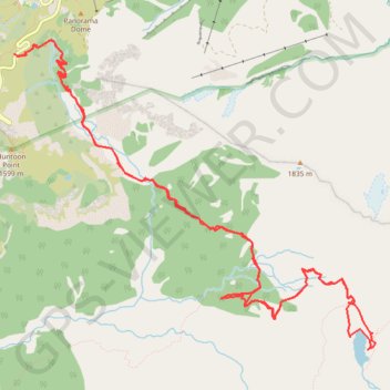
Name: Lake Ann GPS track, route, trail
Start: Mount Baker Highway, Whatcom County, Washington, United States (48.85011 -121.68652)
Coordinates: 48.82655 -121.68652 48.85133 -121.64276
Topography: Whatcom County topographic map
Other GPS tracks
Click on a GPS track to view route, its statistics and profile.
Chain Lakes and Wild Goose Trails Loop
United States > Washington > Whatcom County
Loop hike via Bagley Dam, Chain Lakes Trail, Bagley Lakes, Iceberg Lake, Mazama Lake, Wild Goose Trail, Terminal Lake and Heather Meadows in the Mount Baker Wilderness. #Hike #Loop #Lake #Nature #Mountain #River #Forest #Wilderness
Distance: 7.7 mi • Elevation gain: 2,044 ft • Maximum elevation: 5,466 ft
Northern part of the Pacific Crest Trail (PCT)
United States > Oregon > Klamath County
Hike on the Pacific Crest National Scenic Trail from Crater Lake to Canada Border through Oregon and Washington along the Sierra Nevada and Cascade mountain ranges. #Hike #Mountain #SierraNevada #Cascade #Nature #Forest #Park #PCT
Distance: 744.6 mi • Elevation gain: 145,367 ft • Maximum elevation: 7,569 ft