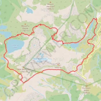
Chain Lakes and Wild Goose Trails Loop
Loop hike via Bagley Dam, Chain Lakes Trail, Bagley Lakes, Iceberg Lake, Mazama Lake, Wild Goose Trail, Terminal Lake and Heather Meadows in the Mount Baker Wilderness. #Hike #Loop #Lake #Nature #Mountain #River #Forest #Wilderness
- Distance: 7.7 mi
- Elevation gain: 2,044 ft
- Maximum elevation: 5,466 ft
- Elevation loss: 2,041 ft
- Minimum elevation: 4,213 ft
- Moving time: 4 h 22 m
- Moving speed: 1.8 mph
- Maximum speed: 3.7 mph
- Total time: 7 h 16 m
- Global speed: 1.1 mph
- Date: 08/20/1998
Interactive map
GPS track profile
About this GPS track
Name: Chain Lakes and Wild Goose Trails Loop GPS track, route, trail
Coordinates: 48.84334 -121.72240 48.86180 -121.68229
Topography: Whatcom County topographic map
Other GPS tracks
Click on a GPS track to view route, its statistics and profile.
Northern part of the Pacific Crest Trail (PCT)
United States > Oregon > Klamath County
Hike on the Pacific Crest National Scenic Trail from Crater Lake to Canada Border through Oregon and Washington along the Sierra Nevada and Cascade mountain ranges. #Hike #Mountain #SierraNevada #Cascade #Nature #Forest #Park #PCT
Distance: 744.6 mi • Elevation gain: 145,367 ft • Maximum elevation: 7,569 ft