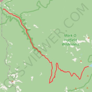
Eagle Creek and Falls
Hike from Columbia River to the Wahtum Lake along Eagle Creek via Metlako Falls, Sorenson Falls, Punch Bowl Falls, Four Mile Falls, Wy east Falls, Grand Union Falls, Tunnel Falls and Twister Falls in the Mark O. Hatfield Wilderness. #Hike #River #Falls #Canyon #Forest #Mountain #Lake #Wilderness
- Distance: 13.1 mi
- Elevation gain: 5,833 ft
- Maximum elevation: 3,753 ft
- Elevation loss: 2,234 ft
- Minimum elevation: 138 ft
Interactive map
GPS track profile
About this GPS track
Name: Eagle Creek and Falls GPS track, route, trail
End: Chindere Cutoff Trail #406M, Hood River County, Oregon, United States (45.58111 -121.80109)
Coordinates: 45.56448 -121.91966 45.63727 -121.80097
Topography: Hood River County topographic map, elevation, terrain
Other GPS tracks
Click on a GPS track to view its route, statistics and profile.
Punchbowl Falls via Eagle Creek Trail in Columbia River Gorge National Scenic Area
United States > Oregon > Multnomah County
The hike to Punchbowl Falls via the Eagle Creek Trail offers a beautiful and immersive experience among lush forests and dramatic landscapes. Along the route, hikers can enjoy breathtaking views of cascading waterfalls, such as Metlako Falls and Twister Falls, while navigating sections of the trail that follow…
Distance: 5.6 mi • Elevation gain: 2,018 ft • Maximum elevation: 640 ft
Northern part of the Pacific Crest Trail (PCT)
United States > Oregon > Klamath County
Hike on the Pacific Crest National Scenic Trail from Crater Lake to Canada Border through Oregon and Washington along the Sierra Nevada and Cascade mountain ranges. #Hike #Mountain #SierraNevada #Cascade #Nature #Forest #Park #PCT
Distance: 744.6 mi • Elevation gain: 145,367 ft • Maximum elevation: 7,569 ft
Expedition to Sedum Ridge
United States > Oregon > Multnomah County
Distance: 133.4 mi • Elevation gain: 16,709 ft • Maximum elevation: 3,835 ft
Cascade Locks - Sisters
États-Unis d'Amérique > Oregon > Hood River County > Cascade Locks
Vélo. En aller simple entre Cascade Locks et Sisters. #Vélo
Distance: 199.0 mi • Elevation gain: 19,505 ft • Maximum elevation: 4,823 ft