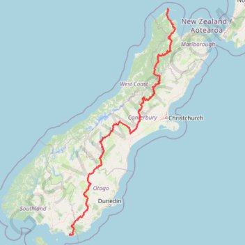
Tour Te Waipounamu
Bikepacking race through the South Island of New Zealand. #Bike #Race #Island #Sea #Pacific #Ocean #Nature #Mountain #Forest #Countryside
- Distance: 820.8 mi
- Elevation gain: 76,647 ft
- Maximum elevation: 6,385 ft
- Elevation loss: 76,621 ft
- Minimum elevation: 0 ft
- Moving time: 4 d 12 h
- Moving speed: 7.6 mph
- Maximum speed: 37.2 mph
- Total time: 5 d 22 h
- Global speed: 5.8 mph
- Date: 01/27/2024
Interactive map
GPS track profile
About this GPS track
Name: Tour Te Waipounamu GPS track, route, trail
Start: Wharariki Road, Port Pūponga, Tasman District, Tasman, New Zealand (-40.50925 172.68933)
Coordinates: -46.67414 168.99842 -40.50042 172.98516
Other GPS tracks
Click on a GPS track to view route, its statistics and profile.
Lyttelton to Sumner Walk
New Zealand > Canterbury > Christchurch City > Banks Peninsula Community > Lyttelton
Hike from Lyttelton to Sumner via Chalmers Track, Mount Pleasant Bluffs Track, Summit Road and Windsor Castle in the Tauhinu-Korokio Scenic Reserve and the Greenwood Park. #Hike #Walk #Nature #Mountain #Park #Forest #Sea #Pacific #Ocean
Distance: 4.4 mi • Elevation gain: 1,348 ft • Maximum elevation: 1,371 ft
Pigeon Bay Walkway - Whitehead Bay
New Zealand > Canterbury > Christchurch City > Banks Peninsula Community > Pigeon Bay
#Hike
Distance: 9.8 mi • Elevation gain: 1,604 ft • Maximum elevation: 472 ft
Lake Tekapo - Lake Pukaki - Glenntanner
New Zealand > Canterbury > Mackenzie District > Lake Tekapo
#Bike
Distance: 49.6 mi • Elevation gain: 1,985 ft • Maximum elevation: 2,464 ft
Arrowton - Wanaka
New Zealand > Otago > Queenstown-Lakes District > Arrowtown
#Bike
Distance: 32.7 mi • Elevation gain: 2,825 ft • Maximum elevation: 3,550 ft
Murchison - Reefton
New Zealand > Tasman > Tasman District > Murchison
#Bike
Distance: 75.9 mi • Elevation gain: 5,991 ft • Maximum elevation: 2,260 ft