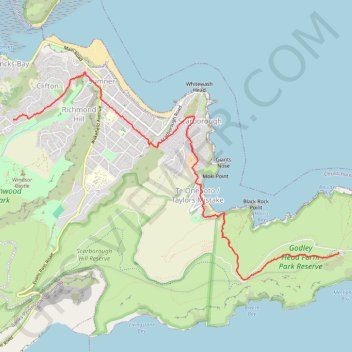
Clifton to Godley Head
Hike from Clifton to Godley Head via Sumner, Scarborough and Taylors Mistake. #Hike #Nature #Sea #Pacific #Ocean #Coast
- Distance: 5.2 mi
- Elevation gain: 1,168 ft
- Maximum elevation: 715 ft
- Elevation loss: 1,253 ft
- Minimum elevation: 13 ft
- Moving time: 1 h 46 m
- Moving speed: 2.9 mph
- Maximum speed: 6.4 mph
- Total time: 1 h 48 m
- Global speed: 2.9 mph
- Date: 03/08/2024
Interactive map
GPS track profile
About this GPS track
Name: Clifton to Godley Head GPS track, route, trail
Coordinates: -43.59250 172.74435 -43.56744 172.79848
Other GPS tracks
Click on a GPS track to view route, its statistics and profile.
Lyttelton to Sumner Walk
New Zealand > Canterbury > Christchurch City > Banks Peninsula Community > Lyttelton
Hike from Lyttelton to Sumner via Chalmers Track, Mount Pleasant Bluffs Track, Summit Road and Windsor Castle in the Tauhinu-Korokio Scenic Reserve and the Greenwood Park. #Hike #Walk #Nature #Mountain #Park #Forest #Sea #Pacific #Ocean
Distance: 4.4 mi • Elevation gain: 1,348 ft • Maximum elevation: 1,371 ft