Profitis Ilias et Katergo
Randonnée entre Folegandros et Karavostasis. #Randonnée
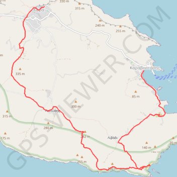
- Distance: 7.3 mi
- Elevation gain: 1,650 ft
- Maximum elevation: 1,050 ft
- Elevation loss: 2,329 ft
- Minimum elevation: -10 ft
- Moving time: 3 h 26 m
- Moving speed: 2.1 mph
- Maximum speed: 3.6 mph
- Total time: 4 h 15 m
- Global speed: 1.7 mph
- Date: 07/16/2013
Interactive map
GPS track profile
About this GPS track
Name: Profitis Ilias et Katergo GPS track, route, trail
Coordinates: 36.59384 24.91255 36.62869 24.95336
Other GPS tracks
Click on a GPS track to view route, its statistics and profile.
Les crêtes du Vighla à Folegandros
Grèce > Égée > Περιφερειακή Ενότητα Θήρας > Chora
Randonnée entre Folegandros et Karavostasis. #Randonnée
Distance: 2.4 mi • Elevation gain: 748 ft • Maximum elevation: 1,047 ft
Les crêtes du Vighla à Folegandros
Grèce > Égée > Περιφερειακή Ενότητα Θήρας > Chora
Distance: 2.4 mi • Elevation gain: 745 ft • Maximum elevation: 1,047 ft