Import a GPX file

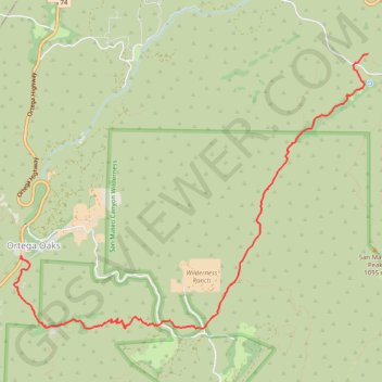
Morgan Trail and Morrell Canyon

Hike from Ortega Oaks via the Bear Canyon, the Morgan Trail and the Morrell Canyon in the San Mateo Canyon Wilderness and the Cleveland National Forest. #Hike #Nature #Canyon #Mountain #Forest #Wilderness

  • Distance: 5.2 mi
  • Elevation gain: 1,145 ft
  • Maximum elevation: 2,913 ft
  • Elevation loss: 210 ft
  • Minimum elevation: 1,975 ft

Interactive map

GPS track profile

About this GPS track

Other GPS tracks

Click on a GPS track to view route, its statistics and profile.

Chiquito Falls (Lyon Canyon Falls)

United States > California > Riverside County

Hike to Chiquito Falls (or Lyon Canyon Falls) via San Juan Trail and Chiquito Trail in the Cleveland National Forest. #Hike #Falls #Nature #Mountain #Forest #River

Distance: 4.3 mi • Elevation gain: 1,122 ft • Maximum elevation: 2,651 ft

Sitton Peak

United States > California > Riverside County

Hike from Ortega Oaks to Sitton Peak via Bear Canyon Trail and Sitton Peak Trail in the Cleveland National Forest and the San Mateo Canyon Wilderness. #Hike #Mountain #Nature #Forest #Canyon #Wilderness

Distance: 4.8 mi • Elevation gain: 1,719 ft • Maximum elevation: 3,238 ft

San Mateo Peak

United States > California > Riverside County

Hike to San Mateo Peak via Morgan Trail and San Mateo Peak Trail in the San Mateo Canyon Wilderness and the Cleveland National Forest. #Hike #Mountain #Nature #Forest #Park

Distance: 2.2 mi • Elevation gain: 781 ft • Maximum elevation: 3,533 ft