Sitton Peak
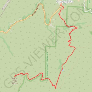
Hike from Ortega Oaks to Sitton Peak via Bear Canyon Trail and Sitton Peak Trail in the Cleveland National Forest and the San Mateo Canyon Wilderness. #Hike #Mountain #Nature #Forest #Canyon #Wilderness
- Distance: 4.8 mi
- Elevation gain: 1,719 ft
- Maximum elevation: 3,238 ft
- Elevation loss: 469 ft
- Minimum elevation: 1,969 ft
Interactive map
GPS track profile
About this GPS track
Name: Sitton Peak GPS track, route, trail
End: Sitton Peak Access Trail, Riverside County, California, United States (33.58717 -117.44610)
Coordinates: 33.58316 -117.44610 33.61309 -117.41977
Topography: Riverside County topographic map
Other GPS tracks
Click on a GPS track to view route, its statistics and profile.