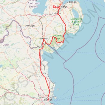
TT22 J4 J2/06 : Dublin à Belfast
- Distance: 155.5 mi
- Elevation gain: 8,560 ft
- Maximum elevation: 1,280 ft
- Elevation loss: 8,419 ft
- Minimum elevation: 0 ft
Interactive map
GPS track profile
About this GPS track
Name: TT22 J4 J2/06 : Dublin à Belfast GPS track, route, trail
Coordinates: 53.33166 -6.44569 54.63485 -5.83396
Other GPS tracks
Click on a GPS track to view route, its statistics and profile.
Howth Bog of Frogs Loop
Irlande > County Dublin > Howth
Distance: 7.4 mi • Elevation gain: 1,391 ft • Maximum elevation: 407 ft
Belfast to Dungannon
United Kingdom > Northern Ireland > County Antrim > Belfast
Bicycle ride from Belfast Big Fish to Dungannon.
Distance: 51.7 mi • Elevation gain: 1,801 ft • Maximum elevation: 246 ft
Trace IRELAND
Distance: 936.2 mi • Elevation gain: 43,829 ft • Maximum elevation: 1,719 ft
RT5-1 Rosslare - Kinsale
Distance: 1,777.3 mi • Elevation gain: 89,833 ft • Maximum elevation: 1,378 ft
CTS-N.Irelandv1.1-Belfast-Titanic>Enniscrone-via antrim coast-209miles
United Kingdom > Northern Ireland > County Down > Belfast
Distance: 208.7 mi • Elevation gain: 13,074 ft • Maximum elevation: 889 ft
RT5-1 Rosslare - Kinsale
Distance: 2,402.9 mi • Elevation gain: 118,488 ft • Maximum elevation: 1,719 ft
Howth Bog of Frogs Loop
Ireland > County Dublin > Howth
Distance: 7.4 mi • Elevation gain: 1,404 ft • Maximum elevation: 407 ft
Lagan & Lough
United Kingdom > Northern Ireland > County Antrim > Tullynacross
Distance: 18.3 mi • Elevation gain: 502 ft • Maximum elevation: 115 ft
TT22 J3 M1/06 : Port de Cork à Dublin
Distance: 222.6 mi • Elevation gain: 14,039 ft • Maximum elevation: 1,719 ft
TT22 J5 V3/06 : Belfast à Belfast
Royaume-Uni > Irlande du Nord > County Antrim > Belfast
Distance: 156.8 mi • Elevation gain: 8,373 ft • Maximum elevation: 866 ft
Newry Canal Towpath
United Kingdom > Northern Ireland > County Armagh > Portadown
Distance: 20.1 mi • Elevation gain: 312 ft • Maximum elevation: 95 ft
Royal canal way
Ireland > County Meath > Enfield
#Bike
Distance: 27.2 mi • Elevation gain: 322 ft • Maximum elevation: 266 ft