Newry Canal Towpath
- Distance: 20.1 mi
- Elevation gain: 312 ft
- Maximum elevation: 95 ft
- Elevation loss: 354 ft
- Minimum elevation: 16 ft
Interactive map
GPS track profile
About this GPS track
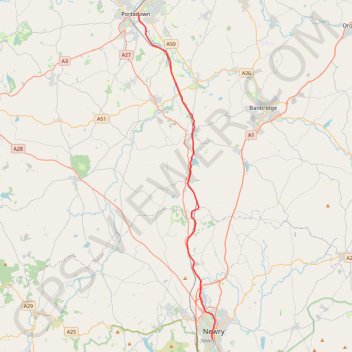
Name: Newry Canal Towpath GPS track, route, trail
Coordinates: 54.17139 -6.43929 54.42460 -6.33519
Other GPS tracks
Click on a GPS track to view route, its statistics and profile.
Belfast to Dungannon
United Kingdom > Northern Ireland > County Antrim > Belfast
Bicycle ride from Belfast Big Fish to Dungannon.
Distance: 51.7 mi • Elevation gain: 1,801 ft • Maximum elevation: 246 ft
RT5-1 Rosslare - Kinsale
Distance: 1,777.3 mi • Elevation gain: 89,833 ft • Maximum elevation: 1,378 ft
CTS-N.Irelandv1.1-Belfast-Titanic>Enniscrone-via antrim coast-209miles
United Kingdom > Northern Ireland > County Down > Belfast
Distance: 208.7 mi • Elevation gain: 13,074 ft • Maximum elevation: 889 ft
TT22 J4 J2/06 : Dublin à Belfast
Irlande > County Dublin > Dublin
Distance: 155.5 mi • Elevation gain: 8,560 ft • Maximum elevation: 1,280 ft
RT5-1 Rosslare - Kinsale
Distance: 2,402.9 mi • Elevation gain: 118,488 ft • Maximum elevation: 1,719 ft