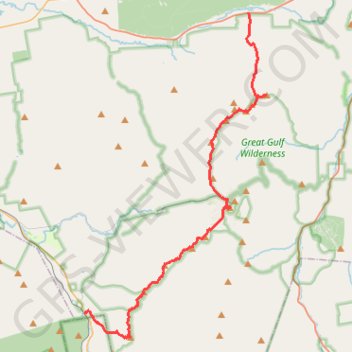
Presidential Range Traverse
Hike via Mount Madison, Mount Adams, Mount Jefferson, Mount Washington, Mount Monroe, Mount Franklin, Mount Eisenhower, Mount Pierce and Mount Jackson in the White Mountain National Forest. #Hike #Mountain #Forest #Nature #Lake
- Distance: 20.1 mi
- Elevation gain: 8,350 ft
- Maximum elevation: 6,270 ft
- Elevation loss: 7,772 ft
- Minimum elevation: 1,309 ft
- Moving time: 13 h 44 m
- Moving speed: 1.5 mph
- Maximum speed: 6.2 mph
- Total time: 16 h 7 m
- Global speed: 1.2 mph
- Date: 08/20/2022
Interactive map
GPS track profile
About this GPS track
Name: Presidential Range Traverse GPS track, route, trail
End: Webster-Jackson Trail, Carroll, Coös County, New Hampshire, United States (44.21514 -71.40792)
Coordinates: 44.20248 -71.40792 44.37145 -71.27652
Topography: Coos County topographic map
Other GPS tracks
Click on a GPS track to view route, its statistics and profile.
Mount Washington, Lion Head and Tuckerman Ravine Loop
United States > New Hampshire > Coos County
Loop hike from Pinkham Notch to Mount Washington via Tuckerman Ravine Trail, Crystal Cascades Falls and Lion Head Trail in the Pinkham Notch Scenic Area, the Mount Washington State Park and the White Mountain National Forest. #Hike #Loop #Mountain #Nature #Forest #Falls #Park
Distance: 7.8 mi • Elevation gain: 4,347 ft • Maximum elevation: 6,270 ft
Mount Adams and Mount Madison Loop
United States > New Hampshire > Coos County > Randolph
Loop hike from Appalachia Trailhead to Mount Adams and Mount Madison via Airline Trail, Gulfside Trail, Madison Spring Hut, Osgood Trail, Watson Path and Valley Way in the Whites Mountains National Forest. #Hike #Loop #Mountain #Nature #Forest
Distance: 8.5 mi • Elevation gain: 4,957 ft • Maximum elevation: 5,755 ft
Mount Isolation, North Isolation and Gulf Peak
United States > New Hampshire > Coos County
Hike to Mount Isolation via Glen Boulder Trail, Gulf Peak, Davis Path, North Isolation and Isolation Trail in the White Mountain National Forest, the Pinkham North Scenic Area and the Presidential Range-Dry River Wilderness. #Hike #Mountain #Nature #Forest #Wilderness
Distance: 10.8 mi • Elevation gain: 4,629 ft • Maximum elevation: 5,157 ft
Mount Jefferson
United States > New Hampshire > Coos County
Hike from Madison Spring Hut to Mount Jefferson via Star Lake, Mount Adams, Israel Ridge, Gulfside Trail and Mount Jefferson Trail in the Great Gulf Wilderness and the White Mountain National Forest. #Hike #Mountain #Nature #Forest #Wilderness
Distance: 3.1 mi • Elevation gain: 1,713 ft • Maximum elevation: 5,755 ft