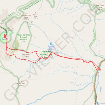
Mount Washington, Lion Head and Tuckerman Ravine Loop
Loop hike from Pinkham Notch to Mount Washington via Tuckerman Ravine Trail, Crystal Cascades Falls and Lion Head Trail in the Pinkham Notch Scenic Area, the Mount Washington State Park and the White Mountain National Forest. #Hike #Loop #Mountain #Nature #Forest #Falls #Park
- Distance: 7.8 mi
- Elevation gain: 4,347 ft
- Maximum elevation: 6,270 ft
- Elevation loss: 4,344 ft
- Minimum elevation: 2,024 ft
Interactive map
GPS track profile
About this GPS track
Name: Mount Washington, Lion Head and Tuckerman Ravine Loop GPS track, route, trail
Coordinates: 44.25703 -71.30351 44.27103 -71.25048
Topography: Coos County topographic map
Other GPS tracks
Click on a GPS track to view route, its statistics and profile.
Presidential Range Traverse
United States > New Hampshire > Coos County > Bowman
Hike via Mount Madison, Mount Adams, Mount Jefferson, Mount Washington, Mount Monroe, Mount Franklin, Mount Eisenhower, Mount Pierce and Mount Jackson in the White Mountain National Forest. #Hike #Mountain #Forest #Nature #Lake
Distance: 20.1 mi • Elevation gain: 8,350 ft • Maximum elevation: 6,270 ft