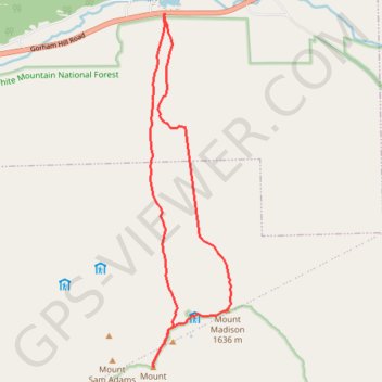
Mount Adams and Mount Madison Loop
Loop hike from Appalachia Trailhead to Mount Adams and Mount Madison via Airline Trail, Gulfside Trail, Madison Spring Hut, Osgood Trail, Watson Path and Valley Way in the Whites Mountains National Forest. #Hike #Loop #Mountain #Nature #Forest
- Distance: 8.5 mi
- Elevation gain: 4,957 ft
- Maximum elevation: 5,755 ft
- Elevation loss: 4,961 ft
- Minimum elevation: 1,306 ft
- Moving time: 7 h 51 m
- Moving speed: 1.1 mph
- Maximum speed: 2.6 mph
- Total time: 10 h 16 m
- Global speed: 0.8 mph
- Date: 08/23/2018
Interactive map
GPS track profile
About this GPS track
Name: Mount Adams and Mount Madison Loop GPS track, route, trail
Coordinates: 44.32055 -71.29220 44.37148 -71.27581
Topography: Coos County topographic map
Other GPS tracks
Click on a GPS track to view route, its statistics and profile.
Presidential Range Traverse
United States > New Hampshire > Coos County > Bowman
Hike via Mount Madison, Mount Adams, Mount Jefferson, Mount Washington, Mount Monroe, Mount Franklin, Mount Eisenhower, Mount Pierce and Mount Jackson in the White Mountain National Forest. #Hike #Mountain #Forest #Nature #Lake
Distance: 20.1 mi • Elevation gain: 8,350 ft • Maximum elevation: 6,270 ft
Mount Jefferson
United States > New Hampshire > Coos County
Hike from Madison Spring Hut to Mount Jefferson via Star Lake, Mount Adams, Israel Ridge, Gulfside Trail and Mount Jefferson Trail in the Great Gulf Wilderness and the White Mountain National Forest. #Hike #Mountain #Nature #Forest #Wilderness
Distance: 3.1 mi • Elevation gain: 1,713 ft • Maximum elevation: 5,755 ft