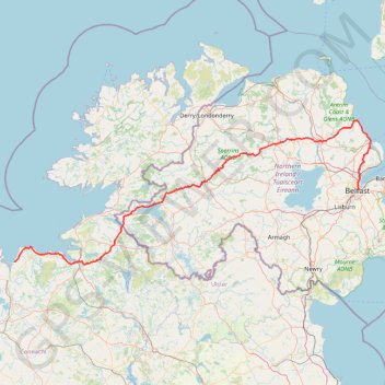
CTS-N.Irelandv1.1-Belfast-Titanic>Enniscrone-via antrim coast-209miles
- Distance: 208.7 mi
- Elevation gain: 13,074 ft
- Maximum elevation: 889 ft
- Elevation loss: 13,061 ft
- Minimum elevation: 0 ft
Interactive map
GPS track profile
About this GPS track
Name: CTS-N.Irelandv1.1-Belfast-Titanic>Enniscrone-via antrim coast-209miles GPS track, route, trail
Coordinates: 54.19749 -9.09619 54.97053 -5.80606
Topography: Belfast topographic map
Other GPS tracks
Click on a GPS track to view route, its statistics and profile.
Cnoc Ramhar
#Hike #Loop #CnocRamhar #Atlantic
Distance: 7.2 mi • Elevation gain: 2,116 ft • Maximum elevation: 1,864 ft
Belfast to Dungannon
United Kingdom > Northern Ireland > County Antrim > Belfast
Bicycle ride from Belfast Big Fish to Dungannon.
Distance: 51.7 mi • Elevation gain: 1,801 ft • Maximum elevation: 246 ft
RT5-1 Rosslare - Kinsale
Distance: 1,777.3 mi • Elevation gain: 89,833 ft • Maximum elevation: 1,378 ft
TT22 J4 J2/06 : Dublin à Belfast
Irlande > County Dublin > Dublin
Distance: 155.5 mi • Elevation gain: 8,560 ft • Maximum elevation: 1,280 ft
RT5-1 Rosslare - Kinsale
Distance: 2,402.9 mi • Elevation gain: 118,488 ft • Maximum elevation: 1,719 ft
Foyle Valley Cycle Route
United Kingdom > Northern Ireland > County Londonderry > Derry/Londonderry
Distance: 5.2 mi • Elevation gain: 207 ft • Maximum elevation: 125 ft
Lagan & Lough
United Kingdom > Northern Ireland > County Antrim > Tullynacross
Distance: 18.3 mi • Elevation gain: 502 ft • Maximum elevation: 115 ft
TT22 J5 V3/06 : Belfast à Belfast
Royaume-Uni > Irlande du Nord > County Antrim > Belfast
Distance: 156.8 mi • Elevation gain: 8,373 ft • Maximum elevation: 866 ft
Newry Canal Towpath
United Kingdom > Northern Ireland > County Armagh > Portadown
Distance: 20.1 mi • Elevation gain: 312 ft • Maximum elevation: 95 ft