The Enchantments
Interactive map
GPS track profile
About this GPS track
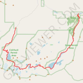
Name: The Enchantments GPS track, route, trail
Start: Stuart Lake Trail, Chelan County, Washington, United States (47.52775 -120.82094)
Coordinates: 47.47695 -120.84400 47.54416 -120.70688
Topography: Chelan County topographic map
Other GPS tracks
Click on a GPS track to view route, its statistics and profile.
Enchantmentpeak on GPSies.com
United States > Washington > Chelan County
Distance: 7.6 mi • Elevation gain: 5,830 ft • Maximum elevation: 8,438 ft
Northern part of the Pacific Crest Trail (PCT)
United States > Oregon > Klamath County
Hike on the Pacific Crest National Scenic Trail from Crater Lake to Canada Border through Oregon and Washington along the Sierra Nevada and Cascade mountain ranges. #Hike #Mountain #SierraNevada #Cascade #Nature #Forest #Park #PCT
Distance: 744.6 mi • Elevation gain: 145,367 ft • Maximum elevation: 7,569 ft
#2c Aasgard Pass, 1m, 2250ft
United States > Washington > Chelan County
Distance: 1.1 mi • Elevation gain: 2,221 ft • Maximum elevation: 7,815 ft