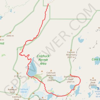
Enchantmentpeak on GPSies.com
- Distance: 7.6 mi
- Elevation gain: 5,830 ft
- Maximum elevation: 8,438 ft
- Elevation loss: 840 ft
- Minimum elevation: 3,402 ft
- Moving time: 1 h 11 m
- Moving speed: 6.4 mph
- Maximum speed: 8.5 mph
- Total time: 1 h 11 m
- Global speed: 6.4 mph
- Date: 07/13/2011
Interactive map
GPS track profile
About this GPS track
Name: Enchantmentpeak on GPSies.com GPS track, route, trail
End: Chelan County, Washington, United States (47.48919 -120.80264)
Coordinates: 47.47724 -120.84402 47.52786 -120.79462
Other GPS tracks
Click on a GPS track to view route, its statistics and profile.
Northern part of the Pacific Crest Trail (PCT)
United States > Oregon > Klamath County
Hike on the Pacific Crest National Scenic Trail from Crater Lake to Canada Border through Oregon and Washington along the Sierra Nevada and Cascade mountain ranges. #Hike #Mountain #SierraNevada #Cascade #Nature #Forest #Park #PCT
Distance: 744.6 mi • Elevation gain: 145,367 ft • Maximum elevation: 7,569 ft
#2c Aasgard Pass, 1m, 2250ft
United States > Washington > Chelan County
Distance: 1.1 mi • Elevation gain: 2,221 ft • Maximum elevation: 7,815 ft