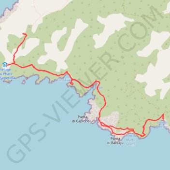
Senetosa tour et phare depuis Tizzano
Randonnée en aller-retour depuis Sartène. #Randonnée
- Distance: 7.8 mi
- Elevation gain: 869 ft
- Maximum elevation: 384 ft
- Elevation loss: 866 ft
- Minimum elevation: -3 ft
- Moving time: 3 h 25 m
- Moving speed: 2.3 mph
- Maximum speed: 3.5 mph
- Total time: 4 h 38 m
- Global speed: 1.7 mph
- Date: 06/19/2015
Interactive map
GPS track profile
About this GPS track
Name: Senetosa tour et phare depuis Tizzano GPS track, route, trail
Start: D 48, Tizzano, Sartène, Corse-du-Sud, Corse, France métropolitaine, 20100, France (41.54927 8.83318)
End: D 48, Tizzano, Sartène, Corse-du-Sud, Corse, France métropolitaine, 20100, France (41.54935 8.83318)
Coordinates: 41.54543 8.79454 41.56441 8.83327
Other GPS tracks
Click on a GPS track to view route, its statistics and profile.
1 LUCENA - MONTPELLIER
Distance: 1,842.0 mi • Elevation gain: 96,785 ft • Maximum elevation: 3,438 ft
1 LUCENA - MONTPELLIER
Espagne > Andalousie > Lucena
Distance: 1,842.0 mi • Elevation gain: 96,785 ft • Maximum elevation: 3,438 ft
Ajaccio - Bastia par le sud
France > Corse > Corse-du-Sud > Ajaccio
Vélo. En aller simple entre Ajaccio et Bastia. #Vélo
Distance: 209.6 mi • Elevation gain: 15,574 ft • Maximum elevation: 1,824 ft
TG6ak
France > Corse > Haute-Corse > Bastia
tour de corse vélo de voyage trace en préparation
Distance: 503.9 mi • Elevation gain: 73,199 ft • Maximum elevation: 4,849 ft