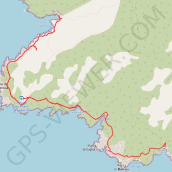
De Tizzano à la Cala di Conca
Interactive map
GPS track profile
About this GPS track
Name: De Tizzano à la Cala di Conca GPS track, route, trail
Start: D 48, Tizzano, Sartène, Corse-du-Sud, Corse, France métropolitaine, 20100, France (41.54878 8.83316)
End: 20100, Corse, France métropolitaine, 20100, France (41.55627 8.81058)
Coordinates: 41.54667 8.79004 41.57555 8.83326
Other GPS tracks
Click on a GPS track to view route, its statistics and profile.
1 LUCENA - MONTPELLIER
Distance: 1,842.0 mi • Elevation gain: 96,785 ft • Maximum elevation: 3,438 ft
1 LUCENA - MONTPELLIER
Espagne > Andalousie > Lucena
Distance: 1,842.0 mi • Elevation gain: 96,785 ft • Maximum elevation: 3,438 ft
Senetosa tour et phare depuis Tizzano
France > Corse > Corse-du-Sud > Tizzano
Randonnée en aller-retour depuis Sartène. #Randonnée
Distance: 7.8 mi • Elevation gain: 869 ft • Maximum elevation: 384 ft
Ajaccio - Bastia par le sud
France > Corse > Corse-du-Sud > Ajaccio
Vélo. En aller simple entre Ajaccio et Bastia. #Vélo
Distance: 209.6 mi • Elevation gain: 15,574 ft • Maximum elevation: 1,824 ft
TG6ak
France > Corse > Haute-Corse > Bastia
tour de corse vélo de voyage trace en préparation
Distance: 503.9 mi • Elevation gain: 73,199 ft • Maximum elevation: 4,849 ft
Conca - Campomoro
France > Corse > Corse-du-Sud > Belvédère-Campomoro > Campomoro
Distance: 21.4 mi • Elevation gain: 2,552 ft • Maximum elevation: 1,289 ft