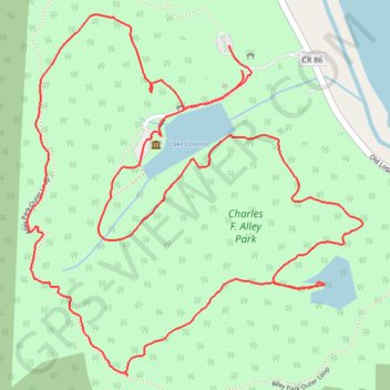
Charles F. Alley Park Loop
Loop hike from Lake Loretta via Alley Park Outer Loop, Twin Lake and George Hutchins Covered Bridge in the Alley Park. #Hike #Loop #Nature #Lake #Forest #Park
- Distance: 3.0 mi
- Elevation gain: 476 ft
- Maximum elevation: 1,070 ft
- Elevation loss: 479 ft
- Minimum elevation: 837 ft
- Moving time: 1 h 15 m
- Moving speed: 2.4 mph
- Maximum speed: 7.9 mph
- Total time: 1 h 23 m
- Global speed: 2.2 mph
- Date: 02/26/2023
Interactive map
GPS track profile
About this GPS track
Name: Charles F. Alley Park Loop GPS track, route, trail
Start: Berne Township, Fairfield County, Ohio, 43130, United States (39.68178 -82.57659)
Coordinates: 39.67463 -82.58312 39.68308 -82.57291
Topography: Fairfield County topographic map
Other GPS tracks
Click on a GPS track to view route, its statistics and profile.
Alley Park trails
United States > Ohio > Fairfield County
Distance: 2.0 mi • Elevation gain: 358 ft • Maximum elevation: 994 ft