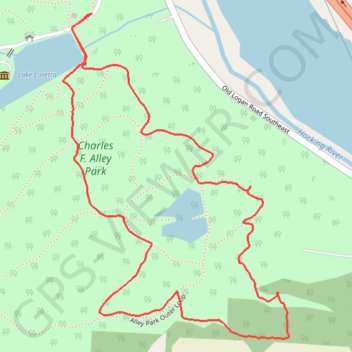
Alley Park trails
- Distance: 2.0 mi
- Elevation gain: 358 ft
- Maximum elevation: 994 ft
- Elevation loss: 358 ft
- Minimum elevation: 840 ft
- Moving time: 41 m 26 s
- Moving speed: 2.8 mph
- Maximum speed: 5.5 mph
- Total time: 47 m 50 s
- Global speed: 2.5 mph
- Date: 04/21/2024
Interactive map
GPS track profile
About this GPS track
Name: Alley Park trails GPS track, route, trail
Start: Berne Township, Fairfield County, Ohio, 43130, United States (39.68144 -82.57658)
End: Berne Township, Fairfield County, Ohio, 43130, United States (39.68147 -82.57656)
Coordinates: 39.67397 -82.57744 39.68147 -82.57067
Topography: Fairfield County topographic map
Other GPS tracks
Click on a GPS track to view route, its statistics and profile.