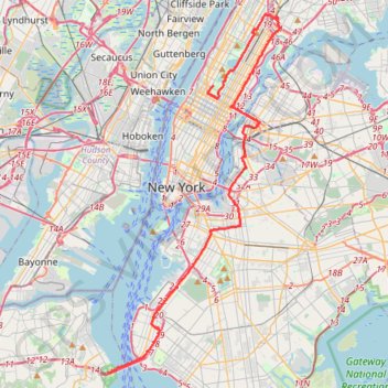
Marathon de New York City
Course à pied / trail. En aller simple. #Course #Trail #Marathon #NewYork
- Distance: 26.9 mi
- Elevation gain: 1,335 ft
- Maximum elevation: 148 ft
- Elevation loss: 1,352 ft
- Minimum elevation: -13 ft
- Moving time: 3 h 21 m
- Moving speed: 8.0 mph
- Maximum speed: 19.2 mph
- Total time: 3 h 21 m
- Global speed: 8.0 mph
- Date: 11/06/2011
Interactive map
GPS track profile
About this GPS track
Name: Marathon de New York City GPS track, route, trail
Coordinates: 40.60215 -74.05954 40.81479 -73.92439
Other GPS tracks
Click on a GPS track to view route, its statistics and profile.
New
United States > New York > New York County > New York
Distance: 55.0 mi • Elevation gain: 4,708 ft • Maximum elevation: 207 ft
Liberty State Park
United States > New Jersey > Hudson County > Jersey City > Communipaw
Distance: 4.3 mi • Elevation gain: 52 ft • Maximum elevation: 16 ft
Central Park Evening walk
United States > New York > New York County > New York
Distance: 2.4 mi • Elevation gain: 226 ft • Maximum elevation: 161 ft
Forever drawn in by the mystique of Kearny Point
United States > New Jersey > Hudson County > Jersey City
bike ride
Distance: 18.4 mi • Elevation gain: 659 ft • Maximum elevation: 115 ft
Morning Run
United States > New York > New York County > New York
Distance: 8.5 mi • Elevation gain: 518 ft • Maximum elevation: 112 ft
Traversée New York
États-Unis d'Amérique > New York > New York
Vélo. En aller simple. #Vélo
Distance: 26.8 mi • Elevation gain: 1,240 ft • Maximum elevation: 141 ft
Montréal - New York
Canada > Québec > Agglomération de Montréal > Montréal
Distance: 396.0 mi • Elevation gain: 13,563 ft • Maximum elevation: 988 ft
Boucle a partir de Houston Station
États-Unis d'Amérique > New York > New York County > New York
Distance: 3.4 mi • Elevation gain: 266 ft • Maximum elevation: 135 ft