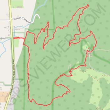
Poo Poo Point - Rescue Loop
- Distance: 4.8 mi
- Elevation gain: 2,149 ft
- Maximum elevation: 1,821 ft
- Elevation loss: 2,149 ft
- Minimum elevation: 174 ft
- Moving time: 2 h 7 m
- Moving speed: 2.3 mph
- Maximum speed: 4.5 mph
- Total time: 2 h 7 m
- Global speed: 2.3 mph
- Date: 05/07/2024
Interactive map
GPS track profile
About this GPS track
Name: Poo Poo Point - Rescue Loop GPS track, route, trail
Coordinates: 47.49217 -122.02206 47.50488 -122.00669
Topography: King County topographic map
Other GPS tracks
Click on a GPS track to view route, its statistics and profile.
Northern part of the Pacific Crest Trail (PCT)
United States > Oregon > Klamath County
Hike on the Pacific Crest National Scenic Trail from Crater Lake to Canada Border through Oregon and Washington along the Sierra Nevada and Cascade mountain ranges. #Hike #Mountain #SierraNevada #Cascade #Nature #Forest #Park #PCT
Distance: 744.6 mi • Elevation gain: 145,367 ft • Maximum elevation: 7,569 ft
Poo Poo Point Rescue Trail
United States > Washington > King County
Distance: 4.4 mi • Elevation gain: 1,860 ft • Maximum elevation: 1,824 ft