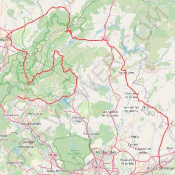
Alcalá de Henares - Cercedilla
En aller simple entre Alcalá de Henares et Cercedilla.
- Distance: 155.1 mi
- Elevation gain: 14,570 ft
- Maximum elevation: 6,102 ft
- Elevation loss: 12,612 ft
- Minimum elevation: 1,942 ft
- Moving time: 6 h 33 m
- Moving speed: 23.6 mph
- Maximum speed: 33.4 mph
- Total time: 6 h 33 m
- Global speed: 23.6 mph
- Date: 12/31/2009
Interactive map
GPS track profile
About this GPS track
Name: Alcalá de Henares - Cercedilla GPS track, route, trail
Coordinates: 40.48127 -4.10870 41.06448 -3.33666
Other GPS tracks
Click on a GPS track to view route, its statistics and profile.
Eurovelo 01 Spain + Portugal
France > Nouvelle-Aquitaine > Pyrénées-Atlantiques > Hendaye
Distance: 1,930.7 mi • Elevation gain: 100,367 ft • Maximum elevation: 4,931 ft
EuroVelo 1 (Spain)
Espagne > Andalousie > Côte occidentale > Ayamonte
Distance: 842.4 mi • Elevation gain: 47,858 ft • Maximum elevation: 4,331 ft
Southern section — European Divide Trail
France > Auvergne-Rhône-Alpes > Drôme > Valence
Distance: 1,506.1 mi • Elevation gain: 139,026 ft • Maximum elevation: 6,578 ft
Buitrago -Hendaye Gravel 438km 4440D+
Espagne > Communauté de Madrid > Buitrago del Lozoya
Distance: 272.4 mi • Elevation gain: 18,950 ft • Maximum elevation: 4,787 ft
1 LUCENA - MONTPELLIER
Distance: 1,842.0 mi • Elevation gain: 96,785 ft • Maximum elevation: 3,438 ft
1 LUCENA - MONTPELLIER
Espagne > Andalousie > Lucena
Distance: 1,842.0 mi • Elevation gain: 96,785 ft • Maximum elevation: 3,438 ft
Stage 26: Valence to Saint-Jean-de-Fos — European Divide Trail
France > Auvergne-Rhône-Alpes > Drôme > Valence
Distance: 1,506.1 mi • Elevation gain: 139,026 ft • Maximum elevation: 6,578 ft
EuroVelo 1 (Spain)
Espagne > Andalousie > Côte occidentale > Ayamonte > Pozo del Camino > Fotea
Distance: 838.7 mi • Elevation gain: 44,754 ft • Maximum elevation: 4,331 ft
01-MCD_305K_HOTPENA_HOTDURAT
Espagne > Castille-La Manche > Señorío de Molina > Zaorejas
Distance: 189.4 mi • Elevation gain: 11,962 ft • Maximum elevation: 4,432 ft
4 Colmenar Manzanares
Espagne > Communauté de Madrid > Colmenar Viejo > San Pedro
Distance: 7.7 mi • Elevation gain: 761 ft • Maximum elevation: 3,297 ft