01-MCD_305K_HOTPENA_HOTDURAT
- Distance: 189.4 mi
- Elevation gain: 11,962 ft
- Maximum elevation: 4,432 ft
- Elevation loss: 12,762 ft
- Minimum elevation: 2,503 ft
Interactive map
GPS track profile
About this GPS track
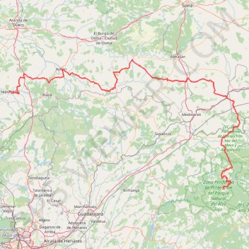
Name: 01-MCD_305K_HOTPENA_HOTDURAT GPS track, route, trail
Coordinates: 40.76207 -3.74975 41.46818 -2.08469
Other GPS tracks
Click on a GPS track to view route, its statistics and profile.
EuroVelo 1 (Spain)
Espagne > Andalousie > Côte occidentale > Ayamonte
Distance: 842.4 mi • Elevation gain: 47,858 ft • Maximum elevation: 4,331 ft
Buitrago -Hendaye Gravel 438km 4440D+
Espagne > Communauté de Madrid > Buitrago del Lozoya
Distance: 272.4 mi • Elevation gain: 18,950 ft • Maximum elevation: 4,787 ft
Southern section — European Divide Trail
France > Auvergne-Rhône-Alpes > Drôme > Valence
Distance: 1,506.1 mi • Elevation gain: 139,026 ft • Maximum elevation: 6,578 ft
Eurovelo 01 Spain + Portugal
France > Nouvelle-Aquitaine > Pyrénées-Atlantiques > Hendaye
Distance: 1,930.7 mi • Elevation gain: 100,367 ft • Maximum elevation: 4,931 ft
1 LUCENA - MONTPELLIER
Distance: 1,842.0 mi • Elevation gain: 96,785 ft • Maximum elevation: 3,438 ft
1 LUCENA - MONTPELLIER
Espagne > Andalousie > Lucena
Distance: 1,842.0 mi • Elevation gain: 96,785 ft • Maximum elevation: 3,438 ft
Stage 26: Valence to Saint-Jean-de-Fos — European Divide Trail
France > Auvergne-Rhône-Alpes > Drôme > Valence
Distance: 1,506.1 mi • Elevation gain: 139,026 ft • Maximum elevation: 6,578 ft
EuroVelo 1 (Spain)
Espagne > Andalousie > Côte occidentale > Ayamonte > Pozo del Camino > Fotea
Distance: 838.7 mi • Elevation gain: 44,754 ft • Maximum elevation: 4,331 ft
Stage 26: Valence to Saint-Jean-de-Fos — European Divide Trail
France > Auvergne-Rhône-Alpes > Drôme > Valence
Distance: 1,012.7 mi • Elevation gain: 101,184 ft • Maximum elevation: 6,578 ft
De Villeneuve-sur-Lot à Guimarães
France > Nouvelle-Aquitaine > Lot-et-Garonne > Villeneuve-sur-Lot
Distance: 1,257.8 mi • Elevation gain: 72,575 ft • Maximum elevation: 4,393 ft
Etape 6 Briviesca - Alaejos
Espagne > Castille-et-León > Briviesca
Distance: 153.7 mi • Elevation gain: 7,182 ft • Maximum elevation: 3,202 ft
Alcalá de Henares - Cercedilla
Espagne > Communauté de Madrid > Alcalá de Henares
En aller simple entre Alcalá de Henares et Cercedilla.
Distance: 155.1 mi • Elevation gain: 14,570 ft • Maximum elevation: 6,102 ft
Pico El Cerrón y Pico Santuy, Sierra de Ayllón, por Cardoso de la Sierra
Espagne > Castille-La Manche > El Cardoso de la Sierra
Randonnée en aller-retour depuis El Cardoso de la Sierra. #Randonnée
Distance: 11.7 mi • Elevation gain: 3,524 ft • Maximum elevation: 7,182 ft