Big South Fork National River and Recreation Area
Scott County Dia
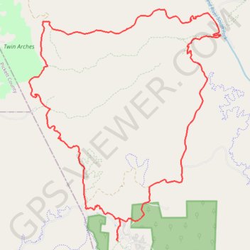
- Distance: 18.1 mi
- Elevation gain: 2,192 ft
- Maximum elevation: 1,598 ft
- Elevation loss: 2,185 ft
- Minimum elevation: 846 ft
Interactive map
GPS track profile
About this GPS track
Name: Big South Fork National River and Recreation Area GPS track, route, trail
Start: Scott County, East Tennessee, Tennessee, United States (36.48910 -84.70238)
Coordinates: 36.48908 -84.73307 36.55354 -84.66638
Topography: Scott County topographic map, elevation, terrain
Other GPS tracks
Click on a GPS track to view its route, statistics and profile.
John Litton Farm Hike Loop
United States > Tennessee > Scott County
Scott State Forest, Fall Branch, Scott County Trail Running
Distance: 4.7 mi • Elevation gain: 522 ft • Maximum elevation: 1,578 ft
Cumberland Valley Loop Trail
United States > Tennessee > Fentress County
Fentress County Dia
Distance: 18.2 mi • Elevation gain: 1,683 ft • Maximum elevation: 1,591 ft
Big Island Loop - Cumberland River South Fork
United States > Tennessee > Scott County
Scott County Dia
Distance: 11.7 mi • Elevation gain: 1,322 ft • Maximum elevation: 1,483 ft