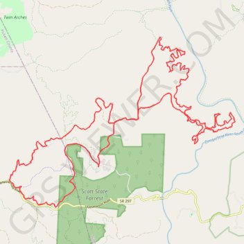
Big South Fork MTB Loop
Mountain Bike loop in the Big South Fork National River and Recreation Area. Cumberland River South Fork. Scott State Forest. #MTB #Loop #River #Forest #Nature
- Distance: 32.4 mi
- Elevation gain: 4,022 ft
- Maximum elevation: 1,614 ft
- Elevation loss: 4,022 ft
- Minimum elevation: 1,168 ft
- Moving time: 5 h 50 m
- Moving speed: 5.5 mph
- Maximum speed: 33.0 mph
- Total time: 7 h 16 m
- Global speed: 4.5 mph
Interactive map
GPS track profile
About this GPS track
Name: Big South Fork MTB Loop GPS track, route, trail
Start: Bandy Creek Loop, Scott County, East Tennessee, Tennessee, United States (36.48808 -84.69839)
End: Bandy Creek Loop, Scott County, East Tennessee, Tennessee, United States (36.48807 -84.69844)
Coordinates: 36.47303 -84.73916 36.53598 -84.63554
Topography: Scott County topographic map, elevation, terrain
Other GPS tracks
Click on a GPS track to view its route, statistics and profile.
John Litton Farm Hike Loop
United States > Tennessee > Scott County
Scott State Forest, Fall Branch, Scott County Trail Running
Distance: 4.7 mi • Elevation gain: 522 ft • Maximum elevation: 1,578 ft
Cumberland Valley Loop Trail
United States > Tennessee > Fentress County
Fentress County Dia
Distance: 18.2 mi • Elevation gain: 1,683 ft • Maximum elevation: 1,591 ft
Scott State Forest
United States > Tennessee > Scott County
Scott County
Distance: 17.4 mi • Elevation gain: 1,273 ft • Maximum elevation: 1,591 ft
Leatherwook Loop Trail
United States > Tennessee > Scott County
Scott County Hiking
Distance: 4.0 mi • Elevation gain: 755 ft • Maximum elevation: 1,467 ft
Big South Fork National River and Recreation Area
United States > Tennessee > Scott County
Scott County Dia
Distance: 18.1 mi • Elevation gain: 2,192 ft • Maximum elevation: 1,598 ft