Les gorges d'Aradena
Interactive map
GPS track profile
About this GPS track
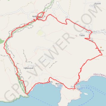
Name: Les gorges d'Aradena GPS track, route, trail
Coordinates: 35.19645 24.04818 35.22506 24.08970
Other GPS tracks
Click on a GPS track to view route, its statistics and profile.
Loutro - Agia Roumeli
Grèce > Région Crète > Περιφερειακή Ενότητα Χανίων > Loutró > Φοίνικας
Randonnée pédestre. En aller simple. #Randonnée
Distance: 9.5 mi • Elevation gain: 1,798 ft • Maximum elevation: 381 ft
Crete J13 Lycos Loutro
Grèce > Région Crète > Περιφερειακή Ενότητα Χανίων > Loutró > Λύκος
Randonnée pédestre. En aller simple. #Randonnée
Distance: 0.9 mi • Elevation gain: 299 ft • Maximum elevation: 210 ft
Loutro - Sweet Water
Grèce > Région Crète > Περιφερειακή Ενότητα Χανίων > Loutró > Φοίνικας
Randonnée en aller-retour depuis Loutro. #Randonnée
Distance: 3.9 mi • Elevation gain: 968 ft • Maximum elevation: 197 ft