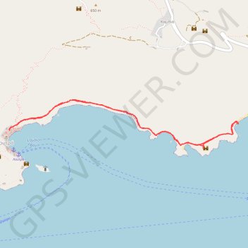
Loutro - Sweet Water
Randonnée en aller-retour depuis Loutro. #Randonnée
- Distance: 3.9 mi
- Elevation gain: 968 ft
- Maximum elevation: 197 ft
- Elevation loss: 961 ft
- Minimum elevation: 0 ft
- Moving time: 1 h 40 m
- Moving speed: 2.3 mph
- Maximum speed: 5.1 mph
- Total time: 1 h 48 m
- Global speed: 2.1 mph
- Date: 07/12/2012
Interactive map
GPS track profile
About this GPS track
Name: Loutro - Sweet Water GPS track, route, trail
Coordinates: 35.19862 24.07881 35.20339 24.10649
Other GPS tracks
Click on a GPS track to view route, its statistics and profile.
Loutro - Agia Roumeli
Grèce > Région Crète > Περιφερειακή Ενότητα Χανίων > Loutró > Φοίνικας
Randonnée pédestre. En aller simple. #Randonnée
Distance: 9.5 mi • Elevation gain: 1,798 ft • Maximum elevation: 381 ft
Crete J13 Lycos Loutro
Grèce > Région Crète > Περιφερειακή Ενότητα Χανίων > Loutró > Λύκος
Randonnée pédestre. En aller simple. #Randonnée
Distance: 0.9 mi • Elevation gain: 299 ft • Maximum elevation: 210 ft