Plana de Sagasti BTT5
- Distance: 16.9 mi
- Elevation gain: 938 ft
- Maximum elevation: 1,516 ft
- Elevation loss: 938 ft
- Minimum elevation: 1,155 ft
- Moving time: 1 h 56 m
- Moving speed: 8.7 mph
- Maximum speed: 21.1 mph
- Total time: 2 h 4 m
- Global speed: 8.2 mph
- Date: 12/04/2009
Interactive map
GPS track profile
About this GPS track
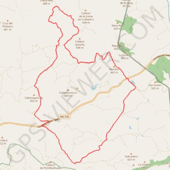
Name: Plana de Sagasti BTT5 GPS track, route, trail
Coordinates: 42.07026 -1.45462 42.14649 -1.38843
Other GPS tracks
Click on a GPS track to view route, its statistics and profile.
Southern section — European Divide Trail
France > Auvergne-Rhône-Alpes > Drôme > Valence
Distance: 1,506.1 mi • Elevation gain: 139,026 ft • Maximum elevation: 6,578 ft
Rutas BardenaNegra 7-6
Espagne > Aragon > Erribera / Ribera > Bardenas Reales de Navarra
Distance: 18.3 mi • Elevation gain: 1,660 ft • Maximum elevation: 2,116 ft
BTT Gran Bardena - Extreme Bardenas
Espagne > Erribera / Ribera > Bardenas Reales de Navarra
Distance: 39.6 mi • Elevation gain: 2,270 ft • Maximum elevation: 2,116 ft
Bardenas_Andorre_Mediterranee
Bardenas_Andorre_Mediterranee
Distance: 628.2 mi • Elevation gain: 80,394 ft • Maximum elevation: 7,264 ft
1 LUCENA - MONTPELLIER
Distance: 1,842.0 mi • Elevation gain: 96,785 ft • Maximum elevation: 3,438 ft
1 LUCENA - MONTPELLIER
Espagne > Andalousie > Lucena
Distance: 1,842.0 mi • Elevation gain: 96,785 ft • Maximum elevation: 3,438 ft
Track liberty-2023-11-28T20:36:34.359Z
France > Nouvelle-Aquitaine > Pyrénées-Atlantiques > Anglet
Distance: 1,263.7 mi • Elevation gain: 172,766 ft • Maximum elevation: 8,012 ft
Bardenas Reales - Tripa Azul
Espagne > Aragon > Erribera / Ribera > Bardenas Reales de Navarra
Distance: 2.6 mi • Elevation gain: 971 ft • Maximum elevation: 2,047 ft
Track liberty-2023-12-31T07:19:49.479Z
France > Nouvelle-Aquitaine > Pyrénées-Atlantiques > Anglet
Distance: 1,264.5 mi • Elevation gain: 173,855 ft • Maximum elevation: 7,956 ft
Stage 26: Valence to Saint-Jean-de-Fos — European Divide Trail
France > Auvergne-Rhône-Alpes > Drôme > Valence
Distance: 1,506.1 mi • Elevation gain: 139,026 ft • Maximum elevation: 6,578 ft
Kiki jour 1
France > Nouvelle-Aquitaine > Pyrénées-Atlantiques > Orthez
Distance: 178.0 mi • Elevation gain: 19,537 ft • Maximum elevation: 4,314 ft
Kiki Jour 2
Espagne > Aragon > Cinco Villas > Tauste
Distance: 88.6 mi • Elevation gain: 7,687 ft • Maximum elevation: 2,667 ft
Stage 26: Valence to Saint-Jean-de-Fos — European Divide Trail
France > Auvergne-Rhône-Alpes > Drôme > Valence
Distance: 1,012.7 mi • Elevation gain: 101,184 ft • Maximum elevation: 6,578 ft
De Villeneuve-sur-Lot à Guimarães
France > Nouvelle-Aquitaine > Lot-et-Garonne > Villeneuve-sur-Lot
Distance: 1,257.8 mi • Elevation gain: 72,575 ft • Maximum elevation: 4,393 ft
Tracé
Espagne > Erribera / Ribera > Fustiñana
Distance: 37.8 mi • Elevation gain: 2,228 ft • Maximum elevation: 2,116 ft