Kiki Jour 2
- Distance: 88.6 mi
- Elevation gain: 7,687 ft
- Maximum elevation: 2,667 ft
- Elevation loss: 7,339 ft
- Minimum elevation: 814 ft
Interactive map
GPS track profile
About this GPS track
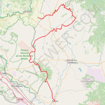
Name: Kiki Jour 2 GPS track, route, trail
Coordinates: 41.92042 -1.43516 42.41962 -1.10796
Other GPS tracks
Click on a GPS track to view route, its statistics and profile.
Notre haute route pyrénéenne (HRP)
France > Nouvelle-Aquitaine > Pyrénées-Atlantiques > Hendaye
Traversé des Pyrénées d'Hendaye à Banyuls-sur-Mer. #Randonnée #Montagne #Pyrénées #Océan #Atlantique #Mer #Méditerranée #Nature #Forêt #HRP
Distance: 438.2 mi • Elevation gain: 149,370 ft • Maximum elevation: 9,774 ft
Camino Francés (Chemin des Français)
France > Nouvelle-Aquitaine > Pyrénées-Atlantiques > Saint-Jean-Pied-de-Port > Larroinea
Pèlerinage de Saint-Jacques-de-Compostelle depuis Saint-Jean-Pied-de-Port. #Randonnée #Compostelle #Espagne #Pyrénées #Nature #Campagne #Montagne #Cantabrica #Cantabrique
Distance: 466.6 mi • Elevation gain: 38,353 ft • Maximum elevation: 4,954 ft
Trace 4X4 traversée des Pyrénées
France > Occitanie > Pyrénées-Orientales > Collioure
De Collioure à Saint-Jean-Pied-de-Port avec une boucle dans les Bardenas. #Pyrénées
Distance: 741.1 mi • Elevation gain: 105,617 ft • Maximum elevation: 6,755 ft
Southern section — European Divide Trail
France > Auvergne-Rhône-Alpes > Drôme > Valence
Distance: 1,506.1 mi • Elevation gain: 139,026 ft • Maximum elevation: 6,578 ft
HRP à contre-courant
France > Occitanie > Pyrénées-Orientales > Cerbère
Randonnée entre Cerbère et Hendaye. Haute route pyrénéenne. #Randonnée #HRP #Pyrénées #Montagne #Mer #Méditerranée #Océan #Atlantique #Nature
Distance: 502.0 mi • Elevation gain: 172,221 ft • Maximum elevation: 10,161 ft
Trace 4X4 Pyrénées traversée
France > Occitanie > Pyrénées-Orientales > Collioure
Distance: 740.8 mi • Elevation gain: 104,879 ft • Maximum elevation: 6,755 ft
Chemin de Saint-Jacques-de-Compostelle de Saint-Germain-des-Prés à Cap Finisterre
France > Centre-Val de Loire > Loiret > Saint-Germain-des-Prés > Montantaume
Randonnée. En aller simple entre Saint-Germain-des-Prés et Fisterra. #Randonnée #Compostelle
Distance: 1,358.7 mi • Elevation gain: 141,211 ft • Maximum elevation: 5,276 ft
Haute route pyrénéenne (HRP)
France > Occitanie > Pyrénées-Orientales > Banyuls-sur-Mer
Distance: 438.4 mi • Elevation gain: 148,314 ft • Maximum elevation: 9,767 ft
Btt - Ruta 1 - Bardenas Reales
Espagne > Erdialdea / Zona Media > Carcastillo
Distance: 17.8 mi • Elevation gain: 728 ft • Maximum elevation: 1,552 ft
BTT Gran Bardena - Extreme Bardenas
Espagne > Erribera / Ribera > Bardenas Reales de Navarra
Distance: 39.6 mi • Elevation gain: 2,270 ft • Maximum elevation: 2,116 ft
Plana de Sagasti BTT5
Espagne > Aragon > Erribera / Ribera > Bardenas Reales de Navarra
Distance: 16.9 mi • Elevation gain: 938 ft • Maximum elevation: 1,516 ft
Rutas BardenaNegra 7-6
Espagne > Aragon > Erribera / Ribera > Bardenas Reales de Navarra
Distance: 18.3 mi • Elevation gain: 1,660 ft • Maximum elevation: 2,116 ft
Traversée des Pyrénées
France > Nouvelle-Aquitaine > Pyrénées-Atlantiques > Hendaye > Haïcabia
Randonnée entre Hendaye et Banyuls-sur-Mer. Pays Basque. #Randonnée #PaysBasque #Pyrénées #Montagne #Nature
Distance: 486.9 mi • Elevation gain: 168,711 ft • Maximum elevation: 11,158 ft
Parc Naturel des Bardenas Reales
Espagne > Erribera / Ribera > Bardenas Reales de Navarra
VTT. En aller-retour. #VTT
Distance: 7.4 mi • Elevation gain: 591 ft • Maximum elevation: 1,358 ft
Trace 4X4 Pyrénées traversée
France > Occitanie > Pyrénées-Orientales > Collioure
Distance: 740.8 mi • Elevation gain: 104,879 ft • Maximum elevation: 6,755 ft
BTT Bardenas 8 - Valdenovillas - Sancho Abarca
Espagne > Erribera / Ribera > Bardenas Reales de Navarra
Distance: 20.5 mi • Elevation gain: 1,722 ft • Maximum elevation: 2,041 ft
Transpyrenees
Espagne > Pays basque autonome > Basse-Bidassoa > Fontarrabie
Transpyrenees
Distance: 687.0 mi • Elevation gain: 114,587 ft • Maximum elevation: 7,326 ft
Trace 4X4 Pyrénées traversée.
France > Occitanie > Pyrénées-Orientales > Collioure
Distance: 880.7 mi • Elevation gain: 131,732 ft • Maximum elevation: 6,755 ft
Compostelle a Velo - ESPAGNE
Espagne > Pirinioak / Pirineo > Roncevaux
Distance: 611.1 mi • Elevation gain: 45,466 ft • Maximum elevation: 4,938 ft
1 LUCENA - MONTPELLIER
Distance: 1,842.0 mi • Elevation gain: 96,785 ft • Maximum elevation: 3,438 ft
Bardenas_Andorre_Mediterranee
Bardenas_Andorre_Mediterranee
Distance: 628.2 mi • Elevation gain: 80,394 ft • Maximum elevation: 7,264 ft
Transpyrenees 2021- SPAIN
Espagne > Catalogne > Haut-Ampurdan > Llançà
Distance: 642.7 mi • Elevation gain: 96,450 ft • Maximum elevation: 7,913 ft
1 LUCENA - MONTPELLIER
Espagne > Andalousie > Lucena
Distance: 1,842.0 mi • Elevation gain: 96,785 ft • Maximum elevation: 3,438 ft
HRP à contre-courant - David
France > Occitanie > Pyrénées-Orientales > Cerbère
Distance: 502.1 mi • Elevation gain: 172,231 ft • Maximum elevation: 10,161 ft
Track liberty-2023-11-28T20:36:34.359Z
France > Nouvelle-Aquitaine > Pyrénées-Atlantiques > Anglet
Distance: 1,263.7 mi • Elevation gain: 172,766 ft • Maximum elevation: 8,012 ft
HRP Pyrénées
France > Nouvelle-Aquitaine > Pyrénées-Atlantiques > Hendaye
Distance: 455.6 mi • Elevation gain: 160,653 ft • Maximum elevation: 9,777 ft
CAMINO FRANCES 1ª PARTE 001
France > Nouvelle-Aquitaine > Pyrénées-Atlantiques > Saint-Jean-Pied-de-Port > Larroinea
Distance: 468.2 mi • Elevation gain: 38,419 ft • Maximum elevation: 4,951 ft
Track liberty-2023-11-18T06:38:38.493Z
France > Nouvelle-Aquitaine > Pyrénées-Atlantiques > Saint-Jean-de-Luz
Distance: 804.5 mi • Elevation gain: 86,877 ft • Maximum elevation: 5,190 ft
Track liberty-2023-12-31T07:19:49.479Z
France > Nouvelle-Aquitaine > Pyrénées-Atlantiques > Anglet
Distance: 1,264.5 mi • Elevation gain: 173,855 ft • Maximum elevation: 7,956 ft
Camino Frances Main Track
France > Nouvelle-Aquitaine > Pyrénées-Atlantiques > Saint-Jean-Pied-de-Port > Larroinea
Distance: 534.0 mi • Elevation gain: 50,072 ft • Maximum elevation: 4,941 ft
Trace 4X4 Pyrénées traversée.
France > Occitanie > Pyrénées-Orientales > Collioure
Distance: 628.0 mi • Elevation gain: 68,652 ft • Maximum elevation: 6,745 ft
Stage 26: Valence to Saint-Jean-de-Fos — European Divide Trail
France > Auvergne-Rhône-Alpes > Drôme > Valence
Distance: 1,506.1 mi • Elevation gain: 139,026 ft • Maximum elevation: 6,578 ft
HRP2019
France > Nouvelle-Aquitaine > Pyrénées-Atlantiques > Hendaye
Distance: 424.5 mi • Elevation gain: 146,404 ft • Maximum elevation: 9,810 ft
Bardenas Reales - Tripa Azul
Espagne > Aragon > Erribera / Ribera > Bardenas Reales de Navarra
Distance: 2.6 mi • Elevation gain: 971 ft • Maximum elevation: 2,047 ft
Trace La Pyrénéenne
France > Nouvelle-Aquitaine > Pyrénées-Atlantiques > Saint-Palais > Sohaburu
Distance: 914.7 mi • Elevation gain: 109,337 ft • Maximum elevation: 6,955 ft
Bardenas Reales - La Piskerra
Espagne > Erribera / Ribera > Bardenas Reales de Navarra
Distance: 5.6 mi • Elevation gain: 755 ft • Maximum elevation: 1,499 ft
(tous)_saint_Jacques_de_Compostelle_1600Km
France > Auvergne-Rhône-Alpes > Haute-Loire > Le Puy-en-Velay
Distance: 1,000.5 mi • Elevation gain: 97,608 ft • Maximum elevation: 4,928 ft
Kiki jour 1
France > Nouvelle-Aquitaine > Pyrénées-Atlantiques > Orthez
Distance: 178.0 mi • Elevation gain: 19,537 ft • Maximum elevation: 4,314 ft
GTF5 - Pyrénées - HRP
France > Occitanie > Pyrénées-Orientales > Arboussols
Distance: 394.3 mi • Elevation gain: 133,537 ft • Maximum elevation: 10,026 ft
5em-jour-La-Pisquerra
Espagne > Erribera / Ribera > Bardenas Reales de Navarra
Distance: 6.2 mi • Elevation gain: 919 ft • Maximum elevation: 1,499 ft
Haute Route Pyrénéenne
France > Occitanie > Pyrénées-Orientales > Banyuls-sur-Mer
Distance: 433.5 mi • Elevation gain: 153,589 ft • Maximum elevation: 10,935 ft
Track
Espagne > Erribera / Ribera > Bardenas Reales de Navarra
Distance: 8.3 mi • Elevation gain: 1,335 ft • Maximum elevation: 1,581 ft
HRP2019
France > Occitanie > Pyrénées-Orientales > Banyuls-sur-Mer
Distance: 424.5 mi • Elevation gain: 146,486 ft • Maximum elevation: 9,810 ft
Stage 26: Valence to Saint-Jean-de-Fos — European Divide Trail
France > Auvergne-Rhône-Alpes > Drôme > Valence
Distance: 1,012.7 mi • Elevation gain: 101,184 ft • Maximum elevation: 6,578 ft
Transpyrenees
Espagne > Pays basque autonome > Basse-Bidassoa > Fontarrabie
Transpyrenees
Distance: 678.3 mi • Elevation gain: 111,001 ft • Maximum elevation: 7,326 ft
GOTOES Export
France > Occitanie > Pyrénées-Orientales > Banyuls-sur-Mer
Created with GOTOES STRAVA TOOLS Version 22.7
Distance: 496.2 mi • Elevation gain: 171,483 ft • Maximum elevation: 10,207 ft
De Villeneuve-sur-Lot à Guimarães
France > Nouvelle-Aquitaine > Lot-et-Garonne > Villeneuve-sur-Lot
Distance: 1,257.8 mi • Elevation gain: 72,575 ft • Maximum elevation: 4,393 ft
Tracks_HRP Atlantique-Mediterranee
France > Nouvelle-Aquitaine > Pyrénées-Atlantiques > Hendaye
Distance: 443.6 mi • Elevation gain: 151,496 ft • Maximum elevation: 9,777 ft