Turnpike Trail to Pipestem or Coopers Mill
Hike along Bluestone River in the Bluestone State Park. #Hike #River #Nature #Forest #Mountain #Park
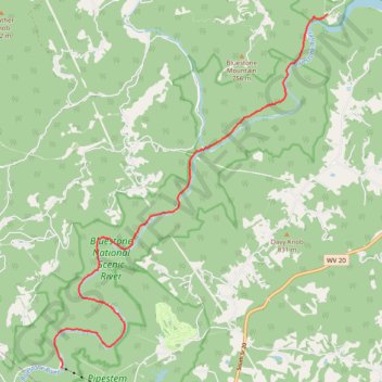
- Distance: 9.4 mi
- Elevation gain: 1,102 ft
- Maximum elevation: 1,601 ft
- Elevation loss: 1,040 ft
- Minimum elevation: 1,414 ft
- Moving time: 28 m 50 s
- Moving speed: 19.6 mph
- Maximum speed: 24.4 mph
- Total time: 28 m 50 s
- Global speed: 19.6 mph
- Date: 03/03/2024
Interactive map
GPS track profile
About this GPS track
Name: Turnpike Trail to Pipestem or Coopers Mill GPS track, route, trail
Start: County Route 20/2, Summers County, West Virginia, 25978, United States (37.61150 -80.93862)
End: Summers County, West Virginia, United States (37.53786 -81.00881)
Coordinates: 37.53785 -81.01036 37.61150 -80.93862
Topography: Summers County topographic map
Other GPS tracks
Click on a GPS track to view route, its statistics and profile.