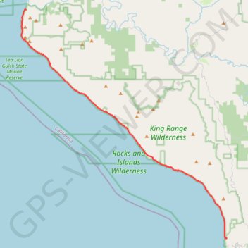
Lost Coast Trail
Hike from Mattole Beach to Black Sands Beach via the Lost Coast Trail, Windy Point, Punta Gorda, Cooskie Creek, Randall Creek, Spanish Flat, Kinsey Creek, Big Creek, Miller Flat, Shipman Creek, Buck Creek, Gitchel Creek and Horse Mountain Creek in the King Range Wilderness. #Hike #Coast #Sea #Pacific #Ocean #Nature #Mountain #Wilderness
- Distance: 26.0 mi
- Elevation gain: 2,356 ft
- Maximum elevation: 174 ft
- Elevation loss: 2,293 ft
- Minimum elevation: -3 ft
Interactive map
GPS track profile
About this GPS track
Name: Lost Coast Trail GPS track, route, trail
Start: Lost Coast Trail, Humboldt County, California, United States (40.28893 -124.35630)
End: Beach Road, Humboldt County, California, 95589, United States (40.04545 -124.07757)
Coordinates: 40.04494 -124.36338 40.28942 -124.07697
Topography: Humboldt County topographic map
Other GPS tracks
Click on a GPS track to view route, its statistics and profile.