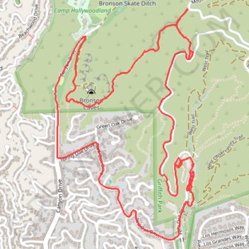
Griffith Park from Bronson Caves
Loop hike through Griffith Park via Bronson Caves Trail, The Tiffany & Co. Foundation Overlook and Western Canyon Road. #Hike #Loop #Park #Nature #Forest #Mountain #Overlook
- Distance: 4.7 mi
- Elevation gain: 928 ft
- Maximum elevation: 1,175 ft
- Elevation loss: 928 ft
- Minimum elevation: 561 ft
- Moving time: 1 h 40 m
- Moving speed: 2.8 mph
- Maximum speed: 6.8 mph
- Total time: 1 h 50 m
- Global speed: 2.6 mph
- Date: 03/04/2024
Interactive map
GPS track profile
About this GPS track
Name: Griffith Park from Bronson Caves GPS track, route, trail
Start: Canyon Drive, Beachwood Canyon, Los Angeles, California, 90068, United States (34.12263 -118.31562)
End: Canyon Drive, Beachwood Canyon, Los Angeles, California, 90068, United States (34.12265 -118.31564)
Coordinates: 34.11235 -118.31642 34.12600 -118.30649
Topography: Los Angeles topographic map
Other GPS tracks
Click on a GPS track to view route, its statistics and profile.
Wonder View Trail
United States > California > Los Angeles
Hike from Lake Hollywood to Griffith Observatory via Burbank Peak Trail, Burbank Peak, Aileen Getty Ridge Trail, Cathuenga Peak, Hugh Hefner Overlook, Mount Lee, Hollywood Sign, Mount Lee Drive, Mulholland Trail, Mount Hollywood Drive and West Observatory Road in the Griffith Park. #Hike #Hollywood #Nature #Mountain #Forest #Overlook
Distance: 5.7 mi • Elevation gain: 1,621 ft • Maximum elevation: 1,729 ft