Import a GPX file

Wonder View Trail

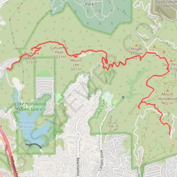
Hike from Lake Hollywood to Griffith Observatory via Burbank Peak Trail, Burbank Peak, Aileen Getty Ridge Trail, Cathuenga Peak, Hugh Hefner Overlook, Mount Lee, Hollywood Sign, Mount Lee Drive, Mulholland Trail, Mount Hollywood Drive and West Observatory Road in the Griffith Park. #Hike #Hollywood #Nature #Mountain #Forest #Overlook

  • Distance: 5.7 mi
  • Elevation gain: 1,621 ft
  • Maximum elevation: 1,729 ft
  • Elevation loss: 1,493 ft
  • Minimum elevation: 965 ft
  • Moving time: 2 h 34 m
  • Moving speed: 2.2 mph
  • Maximum speed: 3.7 mph
  • Total time: 2 h 41 m
  • Global speed: 2.1 mph
  • Date: 02/19/2023

Interactive map

GPS track profile

About this GPS track

Other GPS tracks

Click on a GPS track to view route, its statistics and profile.

Mount Lee and Hollywood Sign

United States > California > Los Angeles County > Los Angeles

Hike to Mount Lee and Hollywood Sign via Brush Canyon Trail, Mulholland Trail and Mount Lee Drive. #Hike #Mountain #Hollywood #Forest #Nature #Canyon

Distance: 2.9 mi • Elevation gain: 1,230 ft • Maximum elevation: 1,640 ft

Griffith Loop Trail

United States > California > Los Angeles

Loop hike in the Griffith Park. #Hike #Loop #Park #Nature #Mountain #Forest #Hollywood

Distance: 2.0 mi • Elevation gain: 571 ft • Maximum elevation: 1,053 ft

Griffith Park from Bronson Caves

United States > California > Los Angeles

Loop hike through Griffith Park via Bronson Caves Trail, The Tiffany & Co. Foundation Overlook and Western Canyon Road. #Hike #Loop #Park #Nature #Forest #Mountain #Overlook

Distance: 4.7 mi • Elevation gain: 928 ft • Maximum elevation: 1,175 ft

Lake Hollywood Loop

United States > California > Los Angeles County > Los Angeles

Loop hike around Hollywood Reservoir. #Hike #Loop #Lake #Hollywood #Nature #Forest

Distance: 3.4 mi • Elevation gain: 492 ft • Maximum elevation: 846 ft

Wisdom Tree (Burbank Peak)

United States > California > Los Angeles County > Los Angeles

Hike to Wisdom Tree at Burbank Peak in Griffith Park. #Hike #Mountain #Nature #Forest #Park

Distance: 0.8 mi • Elevation gain: 653 ft • Maximum elevation: 1,614 ft