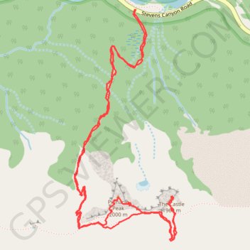
New Track 9/24/22 6:13:29 AM
- Distance: 4.7 mi
- Elevation gain: 2,474 ft
- Maximum elevation: 6,424 ft
- Elevation loss: 2,474 ft
- Minimum elevation: 4,882 ft
- Moving time: 3 h 8 m
- Moving speed: 1.5 mph
- Maximum speed: 10.5 mph
- Total time: 8 h 51 m
- Global speed: 0.5 mph
- Date: 09/24/2022
Interactive map
GPS track profile
About this GPS track
Name: New Track 9/24/22 6:13:29 AM GPS track, route, trail
Start: Pinnacle Peak Trail, Lewis County, Washington, United States (46.76836 -121.73112)
End: Stevens Canyon Road, Lewis County, Washington, United States (46.76835 -121.73118)
Coordinates: 46.75546 -121.73616 46.76836 -121.72783
Topography: Lewis County topographic map
Other GPS tracks
Click on a GPS track to view route, its statistics and profile.
Northern part of the Pacific Crest Trail (PCT)
United States > Oregon > Klamath County
Hike on the Pacific Crest National Scenic Trail from Crater Lake to Canada Border through Oregon and Washington along the Sierra Nevada and Cascade mountain ranges. #Hike #Mountain #SierraNevada #Cascade #Nature #Forest #Park #PCT
Distance: 744.6 mi • Elevation gain: 145,367 ft • Maximum elevation: 7,569 ft