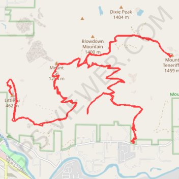
Track (8/12/23, 7:47:57AM)
- Distance: 36.0 mi
- Elevation gain: 12,182 ft
- Maximum elevation: 4,606 ft
- Elevation loss: 12,182 ft
- Minimum elevation: 774 ft
- Moving time: 10 h 51 s
- Moving speed: 3.6 mph
- Maximum speed: 25.0 mph
- Total time: 10 h 7 m
- Global speed: 3.6 mph
- Date: 08/12/2023
Interactive map
GPS track profile
About this GPS track
Name: Track (8/12/23, 7:47:57AM) GPS track, route, trail
Coordinates: 47.48629 -121.75797 47.51410 -121.69515
Topography: King County topographic map
Other GPS tracks
Click on a GPS track to view route, its statistics and profile.
Northern part of the Pacific Crest Trail (PCT)
United States > Oregon > Klamath County
Hike on the Pacific Crest National Scenic Trail from Crater Lake to Canada Border through Oregon and Washington along the Sierra Nevada and Cascade mountain ranges. #Hike #Mountain #SierraNevada #Cascade #Nature #Forest #Park #PCT
Distance: 744.6 mi • Elevation gain: 145,367 ft • Maximum elevation: 7,569 ft