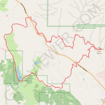
Monument Peak and Big Laguna Lake Loop
Loop hike to Monument Peak via Big Laguna Lake, Pacific Crest National Scenic Trail (PCT) and Foster Point in the Cleveland National Forest and the Laguna Meadow. #Hike #Loop #Mountain #Lake #Nature #PCT #Forest
- Distance: 11.7 mi
- Elevation gain: 1,765 ft
- Maximum elevation: 6,237 ft
- Elevation loss: 1,762 ft
- Minimum elevation: 5,308 ft
Interactive map
GPS track profile
About this GPS track
Name: Monument Peak and Big Laguna Lake Loop GPS track, route, trail
Start: 12038, Sunrise Highway, San Diego County, California, 91948, United States (32.90593 -116.45778)
End: 12027, Sunrise Highway, San Diego County, California, 91948, United States (32.90574 -116.45739)
Coordinates: 32.87447 -116.47066 32.90593 -116.41949
Topography: San Diego County topographic map
Other GPS tracks
Click on a GPS track to view route, its statistics and profile.