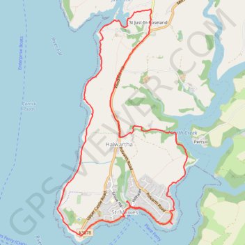
St. Mawes Loop
Loop hike from St. Mawes via St Mawes Castle, St Just-In-Roseland, Halwartha and Porth Creek in the Cornwall National Landscape. #Hike #Loop #Nature #Countryside #Sea #Channel #Coast #River
- Distance: 7.7 mi
- Elevation gain: 771 ft
- Maximum elevation: 269 ft
- Elevation loss: 771 ft
- Minimum elevation: 0 ft
- Moving time: 3 h 31 m
- Moving speed: 2.2 mph
- Maximum speed: 11.4 mph
- Total time: 4 h 6 m
- Global speed: 1.9 mph
- Date: 02/24/2024
Interactive map
GPS track profile
About this GPS track
Name: St. Mawes Loop GPS track, route, trail
Coordinates: 50.15558 -5.02811 50.18436 -5.00238
Other GPS tracks
Click on a GPS track to view route, its statistics and profile.
2022-traces-opencpn
Royaume-Uni > Angleterre > Cornouailles > Falmouth
Distance: 132.5 mi • Elevation gain: 0 ft • Maximum elevation: 0 ft