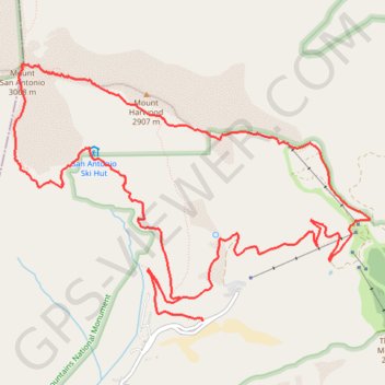
Mount Baldy (or Mount San Antonio) Loop
Loop hike to Mount Baldy from Falls Road via Devils Backbone Trail, Baldy Bowl Trail and San Antonio Ski Hut in Angeles National Forest. #Hike #Loop #Mountain #Nature #Forest #Park #Angeles
- Distance: 10.0 mi
- Elevation gain: 4,252 ft
- Maximum elevation: 10,066 ft
- Elevation loss: 4,252 ft
- Minimum elevation: 6,194 ft
Interactive map
GPS track profile
About this GPS track
Name: Mount Baldy (or Mount San Antonio) Loop GPS track, route, trail
Start: 1, Falls Road, San Bernardino County, California, 91759, United States (34.26627 -117.62692)
End: 3, Falls Road, San Bernardino County, California, 91759, United States (34.26622 -117.62687)
Coordinates: 34.26622 -117.64722 34.28913 -117.60881
Topography: San Bernardino County topographic map
Other GPS tracks
Click on a GPS track to view route, its statistics and profile.
Three T's Trail
United States > California > San Bernardino County
Loop hike to Timber Mountain, Telegraph Peak and Thunder Mountain along the Three T's Trail via Icehouse Canyon Trail, Icehouse Saddle, Mount Baldy Notch and ount Baldy Road in Angeles National Forest. #Hike #Loop #Mountain #Nature #Forest #Angeles
Distance: 15.1 mi • Elevation gain: 5,476 ft • Maximum elevation: 8,944 ft