Durango Meadow
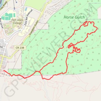
Loop hike from Durango via Horse Gulch Road, Telegraph Trail, Meadow Loop Trail, Stacy's Loop Trail and Cuchillo Trail in the Horse Gulch. #Hike #Loop #Nature #Forest #Mountain
- Distance: 6.5 mi
- Elevation gain: 955 ft
- Maximum elevation: 7,313 ft
- Elevation loss: 958 ft
- Minimum elevation: 6,585 ft
- Moving time: 52 m 29 s
- Moving speed: 7.4 mph
- Maximum speed: 25.6 mph
- Total time: 1 h 26 m
- Global speed: 4.5 mph
- Date: 04/02/2024
Interactive map
GPS track profile
About this GPS track
Name: Durango Meadow GPS track, route, trail
Start: Horse Gulch Road, Durango, La Plata County, Colorado, 81303, United States (37.26429 -107.87181)
Coordinates: 37.26198 -107.87206 37.27718 -107.84139
Topography: Durango topographic map
Other GPS tracks
Click on a GPS track to view route, its statistics and profile.
Dog park and business park
United States > Colorado > La Plata County > Durango
Distance: 18.6 mi • Elevation gain: 1,079 ft • Maximum elevation: 6,650 ft