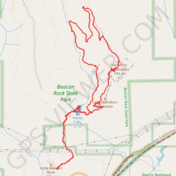
Hamilton Mountain Loop via Hardy and Rodney Falls
Interactive map
GPS track profile
About this GPS track
Name: Hamilton Mountain Loop via Hardy and Rodney Falls GPS track, route, trail
Coordinates: 45.63285 -122.02014 45.66011 -122.00521
Topography: Skamania County topographic map
Other GPS tracks
Click on a GPS track to view route, its statistics and profile.
Northern part of the Pacific Crest Trail (PCT)
United States > Oregon > Klamath County
Hike on the Pacific Crest National Scenic Trail from Crater Lake to Canada Border through Oregon and Washington along the Sierra Nevada and Cascade mountain ranges. #Hike #Mountain #SierraNevada #Cascade #Nature #Forest #Park #PCT
Distance: 744.6 mi • Elevation gain: 145,367 ft • Maximum elevation: 7,569 ft
Cascade Locks - Sisters
États-Unis d'Amérique > Oregon > Hood River County > Cascade Locks
Vélo. En aller simple entre Cascade Locks et Sisters. #Vélo
Distance: 199.0 mi • Elevation gain: 19,505 ft • Maximum elevation: 4,823 ft