Half Dome via Vernal and Nevada Falls
Interactive map
GPS track profile
About this GPS track
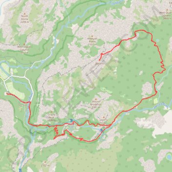
Name: Half Dome via Vernal and Nevada Falls GPS track, route, trail
Coordinates: 37.72181 -119.56621 37.75229 -119.51121
Topography: Mariposa County topographic map
Other GPS tracks
Click on a GPS track to view route, its statistics and profile.
Yosemite North Dome Loop
United States > California > Mariposa County > Curry Village
Loop hike to North Dome via Lower Mirror Lake, Tenaya Creek, Valley Loop Trail, Snow Creek Trail, North Dome Trail, Upper Yosemite Fall Trail, Oh My Gosh Point and Columbia Rock in the Yosemite National Park. #Hike #Loop #Mountain #Nature #Lake #Forest #Fall #Park #Yosemite
Distance: 19.9 mi • Elevation gain: 7,464 ft • Maximum elevation: 8,150 ft
Nevada Fall Loop
United States > California > Mariposa County > Curry Village
Loop hike from Curry Village to Nevada Fall via Happy Isles Bridge, Merced River, John Muir Trail, Mist Trail, Vernal Fall and Clark Point in the Yosemite National Park. #Hike #Loop #Mountain #River #Falls #Nature #Forest #Park #Yosemite
Distance: 8.9 mi • Elevation gain: 3,783 ft • Maximum elevation: 6,066 ft
Vernal and Nevada Falls Loop
United States > California > Mariposa County > Curry Village
Distance: 7.4 mi • Elevation gain: 2,986 ft • Maximum elevation: 6,056 ft
JMT1-16847633
États-Unis d'Amérique > Californie > Inyo County
Distance: 249.4 mi • Elevation gain: 49,836 ft • Maximum elevation: 14,386 ft
Walker - Auberry
États-Unis d'Amérique > Californie > Mono County > Walker
Vélo. En aller simple entre Walker et Auberry. #Vélo
Distance: 220.0 mi • Elevation gain: 21,762 ft • Maximum elevation: 9,970 ft