Import a GPX file

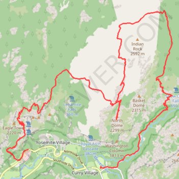
Yosemite North Dome Loop

Loop hike to North Dome via Lower Mirror Lake, Tenaya Creek, Valley Loop Trail, Snow Creek Trail, North Dome Trail, Upper Yosemite Fall Trail, Oh My Gosh Point and Columbia Rock in the Yosemite National Park. #Hike #Loop #Mountain #Nature #Lake #Forest #Fall #Park #Yosemite

  • Distance: 19.9 mi
  • Elevation gain: 7,464 ft
  • Maximum elevation: 8,150 ft
  • Elevation loss: 7,477 ft
  • Minimum elevation: 3,996 ft
  • Moving time: 12 h 42 m
  • Moving speed: 1.6 mph
  • Maximum speed: 16.7 mph
  • Total time: 15 h 2 m
  • Global speed: 1.3 mph
  • Date: 05/19/2012

Interactive map

GPS track profile

About this GPS track

Other GPS tracks

Click on a GPS track to view route, its statistics and profile.

Lower Yosemite Falls Loop

United States > California > Mariposa County > Yosemite Village > Yosemite Lodge

Yosemite National Park. Yosemite Creek. #Hike #Loop #Waterfall #River #Mountain #Forest #Nature #Yosemite

Distance: 1.2 mi • Elevation gain: 164 ft • Maximum elevation: 4,098 ft

Upper Yosemite Falls

United States > California > Mariposa County > Yosemite Village > Yosemite Lodge

Yosemite National Park. Yosemite Creek. #Hike #Waterfall #River #Mountain #Forest #Nature #Yosemite

Distance: 6.3 mi • Elevation gain: 4,879 ft • Maximum elevation: 6,690 ft

Upper Yosemite Fall, Yosemite Point, Oh My Gosh Point and Columbia Rock

United States > California > Mariposa County > Yosemite Village > Yosemite Lodge

Hike from Yosemite Lodge via Upper Yosemite Fall Trail, Columbia Rock, Oh My Gosh Point and Yosemite Point in the Yosemite National Park. #Hike #Mountain #Falls #Overlook #Nature #Forest #Rock #Yosemite #Park

Distance: 9.3 mi • Elevation gain: 7,995 ft • Maximum elevation: 7,031 ft

Tenaya Creek and Mirror Lake

United States > California > Mariposa County > Curry Village

Loop hike along Tenaya Creek via Mirror Lake on Valley Loop Trail in the Yosemite National Park. #Hike #Loop #Nature #River #Forest #Lake #Mountain #Park #Yosemite

Distance: 4.5 mi • Elevation gain: 525 ft • Maximum elevation: 4,190 ft

Yosemite Valley Loop

United States > California > Mariposa County > Yosemite Village

Loop hike from Yosemite Village via the Valley Loop Trail along Merced River in the Yosemite National Park. #Hike #Loop #Nature #River #Forest #Yosemite #Park

Distance: 9.2 mi • Elevation gain: 699 ft • Maximum elevation: 4,068 ft

Half Dome

United States > California > Mariposa County > Curry Village

Hike from Happy Isles to Half Dome via John Muir Trail, Merced River, Vernal Fall and Mist Trail in the Yosemite National Park. #Hike #Mountain #Nature #Forest #River #Fall #Yosemite #Park

Distance: 15.4 mi • Elevation gain: 6,506 ft • Maximum elevation: 8,816 ft

Upper Yosemite Fall

United States > California > Mariposa County > Yosemite Village > Yosemite Lodge

Hike to Upper Yosemite Fall via Columbia Rock in Yosemite National Park. #Hike #Fall #Nature #River #Forest #Park #Yosemite #Mountain

Distance: 3.5 mi • Elevation gain: 3,996 ft • Maximum elevation: 6,716 ft

Columbia Rock

United States > California > Mariposa County > Yosemite Village > Yosemite Lodge

Hike to the Columbia Rock by the Upper Yosemite Fall Trail in the Yosemite National Park. #Hike #Rock #Mountain #Forest #Nature #Yosemite #Park

Distance: 1.0 mi • Elevation gain: 1,171 ft • Maximum elevation: 5,023 ft

Half Dome via Vernal and Nevada Falls

United States > California > Mariposa County > Curry Village

Yosemite National Park. Merced River. #Hike #Mountain #Waterfall #River #Forest #Nature

Distance: 16.6 mi • Elevation gain: 6,739 ft • Maximum elevation: 8,835 ft

JMT1-16847633

États-Unis d'Amérique > Californie > Inyo County

Distance: 249.4 mi • Elevation gain: 49,836 ft • Maximum elevation: 14,386 ft

Walker - Auberry

États-Unis d'Amérique > Californie > Mono County > Walker

Vélo. En aller simple entre Walker et Auberry. #Vélo

Distance: 220.0 mi • Elevation gain: 21,762 ft • Maximum elevation: 9,970 ft