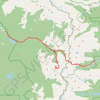
Lone Eagle Peak - Pawnee Pass
Lake Ganby, Monarch Lake, Crater Lake, Triangle Lake, Pawnee Lake, Lake Isabelle, Long Lake. Rocky Mountains. #Hike #RockyMountains
- Distance: 20.4 mi
- Elevation gain: 6,581 ft
- Maximum elevation: 12,546 ft
- Elevation loss: 4,390 ft
- Minimum elevation: 8,317 ft
Interactive map
GPS track profile
About this GPS track
Name: Lone Eagle Peak - Pawnee Pass GPS track, route, trail
Start: Arapaho Bay-Big Rock Loop, CR 6, Grand County, Colorado, United States (40.11907 -105.75865)
Coordinates: 40.06619 -105.75865 40.11980 -105.58380
Topography: Grand County topographic map
Other GPS tracks
Click on a GPS track to view route, its statistics and profile.