Baker Ridge
Ski touring. #Ski #SkiTouring
- Distance: 5.0 mi
- Elevation gain: 5,344 ft
- Maximum elevation: 9,009 ft
- Elevation loss: 52 ft
- Minimum elevation: 3,714 ft
Interactive map
GPS track profile
About this GPS track
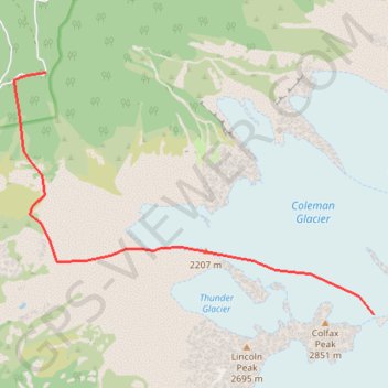
Name: Baker Ridge GPS track, route, trail
End: Coleman-Deming Route, Whatcom County, Washington, United States (48.77234 -121.83491)
Coordinates: 48.77234 -121.90161 48.80200 -121.83491
Topography: Whatcom County topographic map
Other GPS tracks
Click on a GPS track to view route, its statistics and profile.
Northern part of the Pacific Crest Trail (PCT)
United States > Oregon > Klamath County
Hike on the Pacific Crest National Scenic Trail from Crater Lake to Canada Border through Oregon and Washington along the Sierra Nevada and Cascade mountain ranges. #Hike #Mountain #SierraNevada #Cascade #Nature #Forest #Park #PCT
Distance: 744.6 mi • Elevation gain: 145,367 ft • Maximum elevation: 7,569 ft