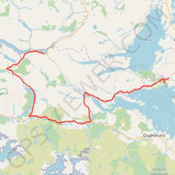
Connemara - Day 4
#Bike
- Distance: 44.8 mi
- Elevation gain: 2,172 ft
- Maximum elevation: 315 ft
- Elevation loss: 2,231 ft
- Minimum elevation: 0 ft
Interactive map
GPS track profile
About this GPS track
Name: Connemara - Day 4 GPS track, route, trail
Coordinates: 53.45125 -9.83183 53.60006 -9.27264
Other GPS tracks
Click on a GPS track to view route, its statistics and profile.
Connemara - Day 1
Ireland > County Galway > Leenaun
#Bike
Distance: 38.6 mi • Elevation gain: 2,136 ft • Maximum elevation: 249 ft
Connemara - Day 3
#Bike
Distance: 38.8 mi • Elevation gain: 2,825 ft • Maximum elevation: 955 ft
Trace IRELAND
Distance: 936.2 mi • Elevation gain: 43,829 ft • Maximum elevation: 1,719 ft
RT5-1 Rosslare - Kinsale
Distance: 1,777.3 mi • Elevation gain: 89,833 ft • Maximum elevation: 1,378 ft
RT5-1 Rosslare - Kinsale
Distance: 2,402.9 mi • Elevation gain: 118,488 ft • Maximum elevation: 1,719 ft
Gable Mount
Randonnée pédestre. En aller-retour. #Randonnée
Distance: 1.9 mi • Elevation gain: 755 ft • Maximum elevation: 1,273 ft
Connemara - Day 5
Ireland > County Galway > Leenaun
#Bike
Distance: 31.3 mi • Elevation gain: 1,909 ft • Maximum elevation: 249 ft